Windows Maps
A Microsoft app that provides voice navigation and turn-by-turn driving, transit, and walking directions.
248 questions
This browser is no longer supported.
Upgrade to Microsoft Edge to take advantage of the latest features, security updates, and technical support.
' cx='32' cy='32' r='32' /%3E%3Ctext x='50%25' y='55%25' dominant-baseline='middle' text-anchor='middle' fill='%23FFF' %3EBM%3C/text%3E%3C/svg%3E)
Hi,
We have requirement to programmatically connect from web application to Esri online and then plot selected feature layer shape file on Bing map.
We are able to connect and read the data from Esri but feature collection that we are getting is different. It is not latitude/longitude format in geometry.
It is in below format.
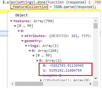
Is anyone have idea how to convert it to latitude/longitude format so that it will plot on bing map properly.
Thanks!
Sam
' cx='32' cy='32' r='32' /%3E%3Ctext x='50%25' y='55%25' dominant-baseline='middle' text-anchor='middle' fill='%23FFF' %3EQ%3C/text%3E%3C/svg%3E)
Hello @Balasaheb Molawade
Just checking in if you have had a chance to see the previous response.
If the below response is helpful, please click "Accept Answer" and upvote it.

The issue is that the data coming through your ESRI service is in a coordinate system other than EPSG:4326 (WGS84 decimal degrees). Looking into the ESRI Feature Service, there is an optional parameter called outSR which is likely what you need: https://developers.arcgis.com/rest/services-reference/enterprise/feature-service.htm Try setting this to GCS_WGS_1984 (guessing based on ESRI docs). Assuming this is correct, you would add the following to your REST URL: &outSR=GCS_WGS_1984
Hi Ricky,
Thanks for your response. I changed the outSR parameter but we got below error.
outSR' parameter is invalid
Please check below REST URL that we used.
Can you please above and let me know if you have solution for it.
Thanks!
I think there are different possible values depending on your configuration in ESRI. Try &outSR=4326 and if that doesn't work, try &outSR=EPSG:4326.
If all else fails I suspect that the coordinates are in Web Mercator projection (EPSG:3857). If the data in the screenshot is meant to appear around (lon: -83.2, lat: 42.2), then the following code can be used to convert those numbers to a value Azure Maps understands:
function MercatorToDegrees(x, y) {
  var lon = (x / 20037508.34) * 180;
  var lat = (y / 20037508.34) * 180;

  lat = 180/Math.PI * (2 * Math.atan(Math.exp(lat * Math.PI / 180)) - Math.PI / 2);
  return [lon, lat];
}
You would use this code like so:
var lonLat = MercatorToDegrees(-9262703, 5195192);
Hi Ricky,
Thanks for your response. Really appreciate for your help.
We used below and its working as per requirment.
var lonLat = MercatorToDegrees(-9262703, 5195192);
It return latitude/longitude but in 0 position it get longitude and 1 position it gives latitude.
Thanks!
' cx='32' cy='32' r='32' /%3E%3Ctext x='50%25' y='55%25' dominant-baseline='middle' text-anchor='middle' fill='%23FFF' %3EAM%3C/text%3E%3C/svg%3E)
@Balasaheb Molawade Glad to hear your issue is resolved after adding var lonLat = MercatorToDegrees(-9262703, 5195192);
If an answer is helpful, please click on  or upvote
  which might help other community members reading this thread.
Correct, longitude should be in position 0 and latitude in position 1. The GeoJSON specification and most advance geospatial tools use this ordering to align with the x, y standard.
Hi Ricky,
We have new requirement to read list of layers define in My content folder. I tried to find REST api to read but not found yet.
When we used below REST API Url then it return all layers that are not required but in that it did not return list of layers that we created.
https://services3.arcgis.com/U26uBjSD32d7xvm2/arcgis/rest/services.
We wanted fetch all layers define below in our account using REST API and show it on Bing map.
Waiting for your reply.
Thanks!
Looks like this documentation may be relevant: https://developers.arcgis.com/python/guide/accessing-and-creating-content/
Note that this would be a better question to ask in an ESRI ArcGIS forum. Note that ESRI ArcGIS is not a Microsoft product.
Hi Ricky,
Thanks for your response.
Thanks!