New Virtual Earth API Release - Virtual Earth 6.1
Today we launched a new version of the Virtual Earth API. The release has a host of new features and takes advantage of some of the capabilities you've been envying on Live Search Maps. Below is a laundry list of new features in Virtual Earth 6.1 that we added today. The good news is that 6.1 is fully backwards compatible to Version 6.0. You just need to update you JavaScript Link URL string to get the new version..The Interactive SDK was updated, as well as, the SDK on MSDN.
Immersive Imagery
Virtual Earth is an industry leader in providing precise views of the world through bird’s eye1 view and panning, and improved 3D model accuracy and resolution, among other features. Precise imagery creates immersive end-user experiences that bring location-based information to life.
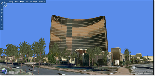
· More Detailed 3D Experiences: With this latest release, the map detail for Las Vegas, NV; Phoenix, AZ; Dallas, TX; and Denver, CO features improvements in 3D model accuracy and resolution detail to reveal more buildings, small terrain features, building textures, and trees that enhance overall realism. This enhanced 3D map detail will soon roll out to the more than 250 cities where 3D models are currently available.
You thought our photo-texturing was good before? Check it out now. This is the Wynn Hotel where I'll be staying in next week during the NAB show. Yes, those are trees!
· Tailored 3D Tours. Media producers can customize video output of 3D fly though tours in six resolutions, in 15 or 30 frames per second, and can add photos and hide or display pushpin icons.
· Bird’s Eye View in 3D. Users can easily toggle bird’s eye view on and off for a seamless end-user experience.
· Bird’s Eye Hybrid View. Customers can nowselect a new map style called Bird’s Eye Hybrid that adds street names to the bird’s eye maps to provide end users better visual context and orientation.
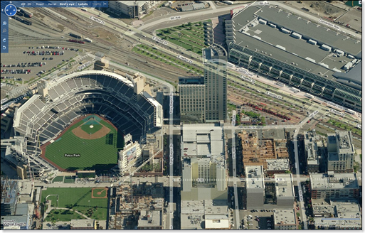
Go Padres!
Enhanced Location Functionality
This latest release of Virtual Earth provides organizations with a host of new features that deliver directions—in more languages—to get users where they’re going faster. With enhanced tools that provide greater flexibility and control over the development of location solutions, organizations can continue to update and enhance their online experience to help them remain competitive and provide satisfying end-user experiences.
· New Walking Directions. When traveling on foot, users in North America and the European Union can now find the most direct route to walk to their destination, ignoring one-way streets, medians, and other detours that pertain to motor vehicles.
· New Traffic-based Routing. Want to take the frontage road and avoid the highway at rush hour? Users can now choose alternate routes based on current traffic flows to get where they’re going faster.
· New Reverse Geocoding. Users in the U.S. can now find the closest street address based only on latitude and longitude coordinates from a GPS or other geospatial device.
· Improved Localized Directions. Organizations can now provide users with localized driving or walking directions in 15 languages, including English, French, Spanish, German, Portuguese, and Italian, among others.
· New Locales. The Virtual Earth dashboard, or navcontrol, is localized to support languages including English for U.S.-based speakers, Japanese, Italian, Spanish for U.S.-based speakers, as well as French for both France and Canada-based speakers.
Enhanced Infrastructure
The Virtual Earth platform is designed for the enterprise user, from features to support. This 6.1 release enhances the platform infrastructure with new cross-browser support to reach more users. The Interactive SDK is available now to demonstrate the latest features and functionality.
· Safari Support. The new map control includes improved support for Apple Safari 2 and new support for Safari 3, enabling Mac users to enjoy many of the features of Virtual Earth that are available on Internet Explorer®.
· Improved Printing Support. Printing support for maps is enhanced to print the driving route in relation to the map. Printing support is also expanded for cross-browser support of Internet Explorer 6 and 7, Firefox 2 for PC, and Safari 2 and 3 for Mac only.
· Updated Interactive SDK. Customers can now access the new Virtual Earth Interactive SDK for online viewing or via download, to demonstrate the new functionality of the Virtual Earth map control.
In addition to the new features we've fixed over 100 "bugs!" Note: a bug isn't necessarily a bug. Sometimes it's a whole new feature, a documentation bug or yes, a real bug. All goodness. And, don't forget, 6.1 is fully backwards compatible to 6.0 (unless, of course, you've downloaded the .js and did some customization of your own - then you're in trouble). Get cracking!
CP
Comments
Anonymous
April 10, 2008
Great Work... FYI The sdk whats new is updated yet... http://msdn2.microsoft.com/en-us/library/bb412561(ide).aspx Still 6.0... Thanks for all the hard work..Anonymous
April 10, 2008
PingBack from http://www.travel-hilarity.com/airline_travel/?p=2601Anonymous
April 10, 2008
Heute wurde Projekt "Goliath" auf http://maps.live.com live geschalten. Projekt Goliath enthält auchAnonymous
April 10, 2008
The comment has been removedAnonymous
April 10, 2008
The comment has been removedAnonymous
April 10, 2008
フナミタカオです。 4月11日遂に VirtualEarth で、東京中心部のビルが3Dになりました。 昨年の9月のRMIXにて、日本も対応する予定という噂がながれてましたが、遂に公開です。 しかも、MacのSafariにも対応する模様(動作未確認ですが...)。Anonymous
April 10, 2008
Virtual Earth / Live Maps: The New Release of Live Maps and Virtual Earth 3D is now Live! Virtual Earth,brAnAnonymous
April 10, 2008
The interactive sdk doesn't seem to have any of the new features and the sdk on MSDN is still for 6.0. When is the stuff for 6.1 going to be published?Anonymous
April 11, 2008
The control has been releases / is publicly available.  Chris Pendleton has the details in his postAnonymous
April 11, 2008
The control has been releases / is publicly available.  Chris Pendleton has the details in his postAnonymous
April 11, 2008
Docs will be online by noon PDT today (different group).Anonymous
April 11, 2008
There was a significant update to our VE/Live Maps platform this week. If you are a partner interestedAnonymous
April 14, 2008
First off looks great, I love the new visuals and 3D data. The overall feel of it is better too. But I have an issue, Is there a way to tell Virtual Earth to continue to use the currently installed version? I have been in the development cycle of a VE application for almost a year now and every time a new version comes out the users (Testers at this point) are forced to install it. This has not been too bad as each release has added something new to the project however, we are nearing release and we simply cannot have 40,000 users with managed workstations upgraded in a timely manner. If there was some lead time before each release or backward compatibility was maintained between releases then we would not have a problem managing. I will have a look to see if this issue is posted in the forums continue to the discussion there and if not I will add it. Eric WAnonymous
April 23, 2008
The comment has been removedAnonymous
April 24, 2008
Marc Schweigert has updated his Intellisense helper for developing Virtual Earth applications in VisualAnonymous
April 30, 2008
is it possible to change when creatign a map object the language or localization? tyAnonymous
May 02, 2008
The comment has been removedAnonymous
May 08, 2008
An alert for you Version 6 API customers out there. We're going to auto-upgrade all Version 6 users toAnonymous
July 29, 2008
You already saw few blog posts and announcements regarding release of July 2008 CTP of Windows Live Tools.Anonymous
July 29, 2008
Cross-posted from http://blogs.msdn.com/vikasahuja You already saw few blog posts and announcements regarding