geo_point_in_polygon()
Calculates whether the geospatial coordinates are inside a polygon or a multipolygon on Earth.
Syntax
geo_point_in_polygon(longitude, latitude, polygon)
Learn more about syntax conventions.
Parameters
| Name | Type | Required | Description |
|---|---|---|---|
| longitude | real |
✔️ | Geospatial coordinate, longitude value in degrees. Valid value is a real number and in the range [-180, +180]. |
| latitude | real |
✔️ | Geospatial coordinate, latitude value in degrees. Valid value is a real number and in the range [-90, +90]. |
| polygon | dynamic |
✔️ | Polygon or multipolygon in the GeoJSON format. |
Returns
Indicates whether the geospatial coordinates are inside a polygon. If the coordinates or polygon is invalid, the query produces a null result.
Note
- The geospatial coordinates are interpreted as represented by the WGS-84 coordinate reference system.
- The geodetic datum used for measurements on Earth is a sphere. Polygon edges are geodesics on the sphere.
- If input polygon edges are straight cartesian lines, consider using geo_polygon_densify() to convert planar edges to geodesics.
Polygon definition and constraints
dynamic({"type": "Polygon","coordinates": [ LinearRingShell, LinearRingHole_1, ..., LinearRingHole_N ]})
dynamic({"type": "MultiPolygon","coordinates": [[LinearRingShell, LinearRingHole_1, ..., LinearRingHole_N ], ..., [LinearRingShell, LinearRingHole_1, ..., LinearRingHole_M]]})
- LinearRingShell is required and defined as a
counterclockwiseordered array of coordinates [[lng_1,lat_1],...,[lng_i,lat_i],...,[lng_j,lat_j],...,[lng_1,lat_1]]. There can be only one shell. - LinearRingHole is optional and defined as a
clockwiseordered array of coordinates [[lng_1,lat_1],...,[lng_i,lat_i],...,[lng_j,lat_j],...,[lng_1,lat_1]]. There can be any number of interior rings and holes. - LinearRing vertices must be distinct with at least three coordinates. The first coordinate must be equal to the last. At least four entries are required.
- Coordinates [longitude, latitude] must be valid. Longitude must be a real number in the range [-180, +180] and latitude must be a real number in the range [-90, +90].
- LinearRingShell encloses at most half of the sphere. LinearRing divides the sphere into two regions. The smaller of the two regions, is chosen.
- LinearRing edge length must be less than 180 degrees. The shortest edge between the two vertices is chosen.
- LinearRings must not cross and must not share edges. LinearRings might share vertices.
- Polygon doesn't necessarily contain its vertices. Point containment in polygon is defined so that if the Earth is subdivided into polygons, every point is contained by exactly one polygon.
Tip
- Using literal Polygon or a MultiPolygon may result in better performance.
- If you want to know if any of the polygons contains a point, try the following steps: Fold the collection of polygons into one multipolygon. Then query this multipolygon. This may improve performance. See the following example.
Examples
The following example finds locations which fall within Manhattan island, excluding the area of Central Park.
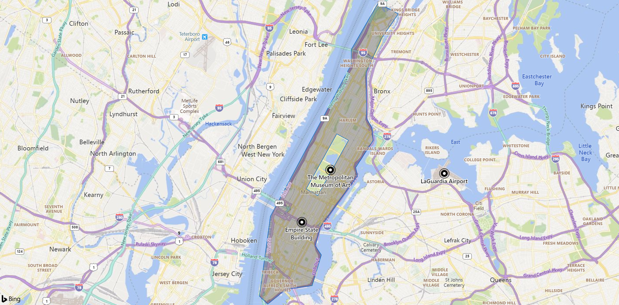
datatable(longitude:real, latitude:real, description:string)
[
    real(-73.985654), 40.748487, 'Empire State Building',           // In Polygon
    real(-73.963249), 40.779525, 'The Metropolitan Museum of Art',  // In exterior of polygon
    real(-73.874367), 40.777356, 'LaGuardia Airport',               // In exterior of polygon
]
| where geo_point_in_polygon(longitude, latitude, dynamic({"type":"Polygon","coordinates":[[[-73.92597198486328,40.87821814104651],[-73.94691467285156,40.85069618625578],[-73.94691467285156,40.841865966890786],[-74.01008605957031,40.7519385984599],[-74.01866912841797,40.704586878965245],[-74.01214599609375,40.699901911003046],[-73.99772644042969,40.70875101828792],[-73.97747039794922,40.71083299030839],[-73.97026062011719,40.7290474687069],[-73.97506713867186,40.734510840309376],[-73.970947265625,40.74543623770158],[-73.94210815429688,40.77586181063573],[-73.9434814453125,40.78080140115127],[-73.92974853515625,40.79691751000055],[-73.93077850341797,40.804454347291006],[-73.93489837646484,40.80965166748853],[-73.93524169921875,40.837190668541105],[-73.92288208007812,40.85770758108904],[-73.9101791381836,40.871728144624974],[-73.92597198486328,40.87821814104651]],[[-73.95824432373047,40.80071852197889],[-73.98206233978271,40.76815921628347],[-73.97309303283691,40.76422632379533],[-73.94914627075195,40.796949998204596],[-73.95824432373047,40.80071852197889]]]}))
Output
| longitude | latitude | description |
|---|---|---|
| -73.985654 | 40.748487 | Empire State Building |
The following example searches for coordinates in a multipolygon.
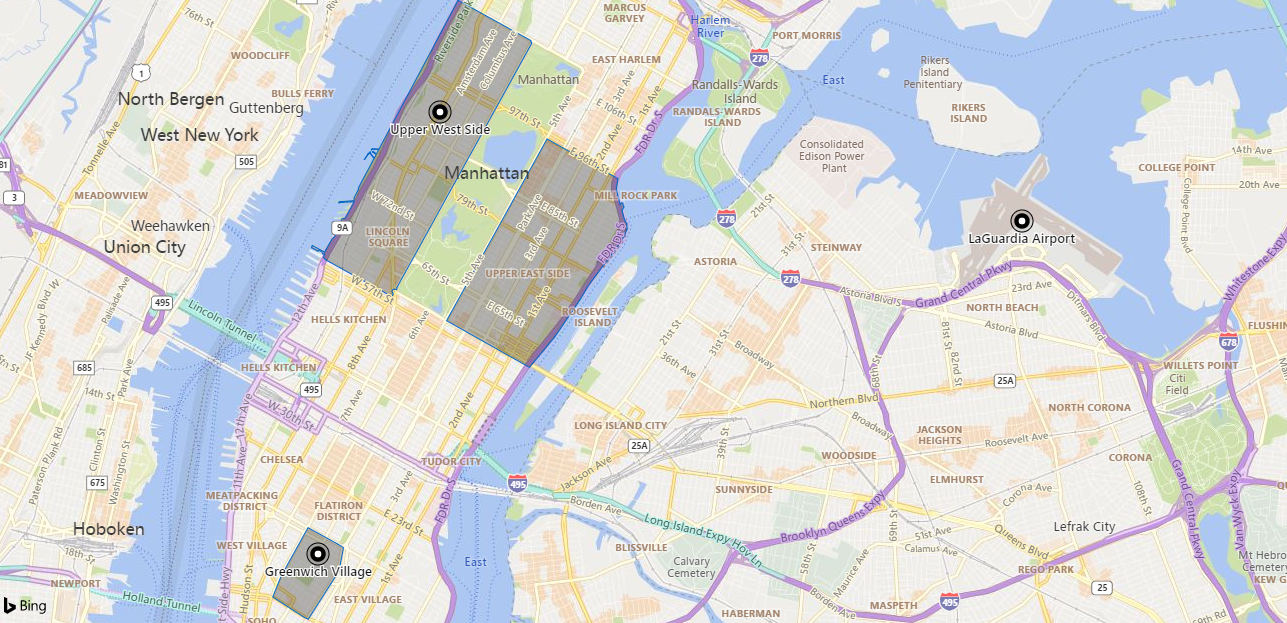
let multipolygon = dynamic({"type":"MultiPolygon","coordinates":[[[[-73.991460000000131,40.731738000000206],[-73.992854491775518,40.730082566051351],[-73.996772,40.725432000000154],[-73.997634685522883,40.725786309886963],[-74.002855946639244,40.728346630056791],[-74.001413,40.731065000000207],[-73.996796995070824,40.73736378205173],[-73.991724524037934,40.735245208931886],[-73.990703782359589,40.734781896080477],[-73.991460000000131,40.731738000000206]]],[[[-73.958357552055688,40.800369095633819],[-73.98143901556422,40.768762584141953],[-73.981548752788598,40.7685590292784],[-73.981565335901905,40.768307084720796],[-73.981754418060945,40.768399727738668],[-73.982038573548124,40.768387823012056],[-73.982268248204349,40.768298621883247],[-73.982384797518051,40.768097213086911],[-73.982320919746599,40.767894461792181],[-73.982155532845766,40.767756204474757],[-73.98238873834039,40.767411004834273],[-73.993650353659021,40.772145571634361],[-73.99415893763998,40.772493009137818],[-73.993831082030937,40.772931787850908],[-73.993891252437052,40.772955194876722],[-73.993962585514595,40.772944653908901],[-73.99401262480508,40.772882846631894],[-73.994122058082397,40.77292405902601],[-73.994136652588594,40.772901870174394],[-73.994301342391154,40.772970028663913],[-73.994281535134448,40.77299380206933],[-73.994376552751078,40.77303955110149],[-73.994294029824005,40.773156243992048],[-73.995023275860802,40.773481196576356],[-73.99508939189289,40.773388475039134],[-73.995013963716758,40.773358035426909],[-73.995050284699261,40.773297153189958],[-73.996240651898916,40.773789791397689],[-73.996195837470992,40.773852356184044],[-73.996098807369748,40.773951805299085],[-73.996179459973888,40.773986954351571],[-73.996095245226442,40.774086186437756],[-73.995572265161172,40.773870731394297],[-73.994017424135961,40.77321375261053],[-73.993935876811335,40.773179512586211],[-73.993861942928888,40.773269531698837],[-73.993822393527211,40.773381758622882],[-73.993767019318497,40.773483981224835],[-73.993698463744295,40.773562141052594],[-73.993358326468751,40.773926888327956],[-73.992622663865575,40.774974056037109],[-73.992577842766124,40.774956016359418],[-73.992527743951555,40.775002110439829],[-73.992469745815342,40.775024159551755],[-73.992403837191887,40.775018140390664],[-73.99226708903538,40.775116033858794],[-73.99217809026365,40.775279293897171],[-73.992059084937338,40.775497598192516],[-73.992125372394938,40.775509075053385],[-73.992226867797001,40.775482211026116],[-73.992329346608813,40.775468900958522],[-73.992361756801131,40.775501899766638],[-73.992386042960277,40.775557180424634],[-73.992087684712729,40.775983970821372],[-73.990927174149746,40.777566878763238],[-73.99039616003671,40.777585065679204],[-73.989461267506471,40.778875124584417],[-73.989175778438053,40.779287524015778],[-73.988868617400072,40.779692922911607],[-73.988871874499793,40.779713738253008],[-73.989219022880576,40.779697895209402],[-73.98927785904425,40.779723439271038],[-73.989409054180143,40.779737706471963],[-73.989498614927044,40.779725044389757],[-73.989596493388234,40.779698146683387],[-73.989679812902509,40.779677568658038],[-73.989752702937935,40.779671244211556],[-73.989842247806507,40.779680752670664],[-73.990040102120489,40.779707677698219],[-73.990137977524839,40.779699769704784],[-73.99033584033225,40.779661794394983],[-73.990430598697046,40.779664973055503],[-73.990622199396725,40.779676064914298],[-73.990745069505479,40.779671328184051],[-73.990872114282197,40.779646007643876],[-73.990961672224358,40.779639683751753],[-73.991057472829539,40.779652352625774],[-73.991157429497036,40.779669775606465],[-73.991242817404469,40.779671367084504],[-73.991255318289745,40.779650782516491],[-73.991294887120119,40.779630209208889],[-73.991321967649895,40.779631796041372],[-73.991359455569423,40.779585883337383],[-73.991551059227476,40.779574821437407],[-73.99141982585985,40.779755280287233],[-73.988886144117032,40.779878898532999],[-73.988939656706265,40.779956178440393],[-73.988926103530844,40.780059292013632],[-73.988911680264692,40.780096037146606],[-73.988919261468567,40.780226094343945],[-73.988381050202634,40.780981074045783],[-73.988232413846987,40.781233144215555],[-73.988210420831663,40.781225482542055],[-73.988140000000143,40.781409000000224],[-73.988041288067166,40.781585961353777],[-73.98810029382463,40.781602878305286],[-73.988076449145055,40.781650935001608],[-73.988018059972219,40.781634188810422],[-73.987960792842145,40.781770987031535],[-73.985465811970457,40.785360700575431],[-73.986172704965611,40.786068452258647],[-73.986455862401996,40.785919219081421],[-73.987072345615601,40.785189638820121],[-73.98711901394276,40.785210319004058],[-73.986497781023601,40.785951202887254],[-73.986164628806279,40.786121882448327],[-73.986128422486075,40.786239001331111],[-73.986071135219746,40.786240706026611],[-73.986027274789123,40.786228964236727],[-73.986097637849426,40.78605822569795],[-73.985429321269592,40.785413942184597],[-73.985081137732209,40.785921935110366],[-73.985198833254501,40.785966552197777],[-73.985170502389906,40.78601333415817],[-73.985216218673656,40.786030501816427],[-73.98525509797993,40.785976205511588],[-73.98524273937646,40.785972572653328],[-73.98524962933017,40.785963139855845],[-73.985281779186749,40.785978620950075],[-73.985240032884533,40.786035858136792],[-73.985683885242182,40.786222123919686],[-73.985717529004575,40.786175994668795],[-73.985765660297687,40.786196274858618],[-73.985682871922691,40.786309786213067],[-73.985636270930442,40.786290150649279],[-73.985670722564691,40.786242911993817],[-73.98520511880038,40.786047669212785],[-73.985211035607492,40.786039554883686],[-73.985162639946992,40.786020999769754],[-73.985131636312062,40.786060297019972],[-73.985016964065125,40.78601423719563],[-73.984655078830457,40.786534741807841],[-73.985743787901043,40.786570082854738],[-73.98589227228328,40.786426529019593],[-73.985942854994988,40.786452847880334],[-73.985949561556794,40.78648711396653],[-73.985812373526713,40.786616865357047],[-73.985135209703174,40.78658761889551],[-73.984619428584324,40.786586016349787],[-73.981952458164173,40.790393724337193],[-73.972823037363767,40.803428052816756],[-73.971036786332192,40.805918478839672],[-73.966701,40.804169000000186],[-73.959647,40.801156000000113],[-73.958508540159471,40.800682279767472],[-73.95853274080838,40.800491362464697],[-73.958357552055688,40.800369095633819]]],[[[-73.943592454622546,40.782747908206574],[-73.943648235390199,40.782656161333449],[-73.943870759887162,40.781273026571704],[-73.94345932494096,40.780048275653243],[-73.943213862652243,40.779317588660199],[-73.943004239504688,40.779639495474292],[-73.942716005450905,40.779544169476175],[-73.942712374762181,40.779214856940001],[-73.942535563208608,40.779090956062532],[-73.942893408188027,40.778614093246276],[-73.942438481745029,40.777315235766039],[-73.942244919522594,40.777104088947254],[-73.942074188038887,40.776917846977142],[-73.942002667222781,40.776185317382648],[-73.942620205199006,40.775180871576474],[-73.94285645694552,40.774796600349191],[-73.94293043781397,40.774676268036011],[-73.945870899588215,40.771692257932997],[-73.946618690150586,40.77093339256956],[-73.948664164778933,40.768857624399587],[-73.950069793030679,40.767025088383498],[-73.954418260786071,40.762184104951245],[-73.95650786241211,40.760285256574043],[-73.958787773424007,40.758213471309809],[-73.973015157270069,40.764278692864671],[-73.955760332998182,40.787906554459667],[-73.944023,40.782960000000301],[-73.943592454622546,40.782747908206574]]]]});
let coordinates =
    datatable(longitude:real, latitude:real, description:string)
    [
        real(-73.9741), 40.7914, 'Upper West Side',    // In MultiPolygon
        real(-73.9950), 40.7340, 'Greenwich Village',  // In MultiPolygon
        real(-73.8743), 40.7773, 'LaGuardia Airport',  // In exterior of MultiPolygon
    ];
coordinates
| where geo_point_in_polygon(longitude, latitude, multipolygon)
Output
| longitude | latitude | description |
|---|---|---|
| -73.9741 | 40.7914 | Upper West Side |
| -73.995 | 40.734 | Greenwich Village |
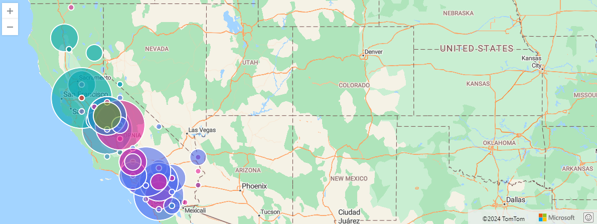
The following example finds storm events in California. The events are filtered by a California state polygon and aggregated by event type and hash.
let california = dynamic({"type":"Polygon","coordinates":[[[-123.233256,42.006186],[-122.378853,42.011663],[-121.037003,41.995232],[-120.001861,41.995232],[-119.996384,40.264519],[-120.001861,38.999346],[-118.71478,38.101128],[-117.498899,37.21934],[-116.540435,36.501861],[-115.85034,35.970598],[-114.634459,35.00118],[-114.634459,34.87521],[-114.470151,34.710902],[-114.333228,34.448009],[-114.136058,34.305608],[-114.256551,34.174162],[-114.415382,34.108438],[-114.535874,33.933176],[-114.497536,33.697668],[-114.524921,33.54979],[-114.727567,33.40739],[-114.661844,33.034958],[-114.524921,33.029481],[-114.470151,32.843265],[-114.524921,32.755634],[-114.72209,32.717295],[-116.04751,32.624187],[-117.126467,32.536556],[-117.24696,32.668003],[-117.252437,32.876127],[-117.329114,33.122589],[-117.471515,33.297851],[-117.7837,33.538836],[-118.183517,33.763391],[-118.260194,33.703145],[-118.413548,33.741483],[-118.391641,33.840068],[-118.566903,34.042715],[-118.802411,33.998899],[-119.218659,34.146777],[-119.278905,34.26727],[-119.558229,34.415147],[-119.875891,34.40967],[-120.138784,34.475393],[-120.472878,34.448009],[-120.64814,34.579455],[-120.609801,34.858779],[-120.670048,34.902595],[-120.631709,35.099764],[-120.894602,35.247642],[-120.905556,35.450289],[-121.004141,35.461243],[-121.168449,35.636505],[-121.283465,35.674843],[-121.332757,35.784382],[-121.716143,36.195153],[-121.896882,36.315645],[-121.935221,36.638785],[-121.858544,36.6114],[-121.787344,36.803093],[-121.929744,36.978355],[-122.105006,36.956447],[-122.335038,37.115279],[-122.417192,37.241248],[-122.400761,37.361741],[-122.515777,37.520572],[-122.515777,37.783465],[-122.329561,37.783465],[-122.406238,38.15042],[-122.488392,38.112082],[-122.504823,37.931343],[-122.701993,37.893004],[-122.937501,38.029928],[-122.97584,38.265436],[-123.129194,38.451652],[-123.331841,38.566668],[-123.44138,38.698114],[-123.737134,38.95553],[-123.687842,39.032208],[-123.824765,39.366301],[-123.764519,39.552517],[-123.85215,39.831841],[-124.109566,40.105688],[-124.361506,40.259042],[-124.410798,40.439781],[-124.158859,40.877937],[-124.109566,41.025814],[-124.158859,41.14083],[-124.065751,41.442061],[-124.147905,41.715908],[-124.257444,41.781632],[-124.213628,42.000709],[-123.233256,42.006186]]]});
StormEvents
| project BeginLon, BeginLat, EventType
| where geo_point_in_polygon(BeginLon, BeginLat, california)
| summarize count() by EventType, hash = geo_point_to_s2cell(BeginLon, BeginLat, 7)
| project geo_s2cell_to_central_point(hash), EventType, count_
| render piechart with (kind=map) // map rendering available in Kusto Explorer desktop
Output
The following example shows how to classify coordinates to polygons using the partition operator.
let Polygons = datatable(description:string, polygon:dynamic)
    [
      "New York city area", dynamic({"type":"Polygon","coordinates":[[[-73.85009765625,40.85744791303121],[-74.16046142578125,40.84290487729676],[-74.190673828125,40.59935608796518],[-73.83087158203125,40.61812224225511],[-73.85009765625,40.85744791303121]]]}),
      "Seattle area",       dynamic({"type":"Polygon","coordinates":[[[-122.200927734375,47.68573021131587],[-122.4591064453125,47.68573021131587],[-122.4755859375,47.468949677672484],[-122.17620849609374,47.47266286861342],[-122.200927734375,47.68573021131587]]]}),
      "Las Vegas",          dynamic({"type":"Polygon","coordinates":[[[-114.9,36.36],[-115.4498291015625,36.33282808737917],[-115.4498291015625,35.84453450421662],[-114.949951171875,35.902399875143615],[-114.9,36.36]]]}),
    ];
let Locations = datatable(longitude:real, latitude:real)
    [
      real(-73.95),  real(40.75), // Somewhere in New York
      real(-122.3),  real(47.6),  // Somewhere in Seattle
      real(-115.18), real(36.16)  // Somewhere in Las Vegas
    ];
Polygons
| project polygonPartition = tostring(pack("description", description, "polygon", polygon))
| partition hint.materialized=true hint.strategy=native by polygonPartition
{
     Locations
     | extend description = parse_json(toscalar(polygonPartition)).description
     | extend polygon = parse_json(toscalar(polygonPartition)).polygon
     | where geo_point_in_polygon(longitude, latitude, polygon)
     | project-away polygon
}
Output
| longitude | latitude | description |
|---|---|---|
| -73.95 | 40.75 | New York city area |
| -122.3 | 47.6 | Seattle area |
| -115.18 | 36.16 | Las Vegas |
See also geo_polygon_to_s2cells().
The following example folds several polygons into one multipolygon and checks locations that fall within the multipolygon.
let Polygons =
    datatable(polygon:dynamic)
    [
        dynamic({"type":"Polygon","coordinates":[[[-73.991460000000131,40.731738000000206],[-73.992854491775518,40.730082566051351],[-73.996772,40.725432000000154],[-73.997634685522883,40.725786309886963],[-74.002855946639244,40.728346630056791],[-74.001413,40.731065000000207],[-73.996796995070824,40.73736378205173],[-73.991724524037934,40.735245208931886],[-73.990703782359589,40.734781896080477],[-73.991460000000131,40.731738000000206]]]}),
        dynamic({"type":"Polygon","coordinates":[[[-73.958357552055688,40.800369095633819],[-73.98143901556422,40.768762584141953],[-73.981548752788598,40.7685590292784],[-73.981565335901905,40.768307084720796],[-73.981754418060945,40.768399727738668],[-73.982038573548124,40.768387823012056],[-73.982268248204349,40.768298621883247],[-73.982384797518051,40.768097213086911],[-73.982320919746599,40.767894461792181],[-73.982155532845766,40.767756204474757],[-73.98238873834039,40.767411004834273],[-73.993650353659021,40.772145571634361],[-73.99415893763998,40.772493009137818],[-73.993831082030937,40.772931787850908],[-73.993891252437052,40.772955194876722],[-73.993962585514595,40.772944653908901],[-73.99401262480508,40.772882846631894],[-73.994122058082397,40.77292405902601],[-73.994136652588594,40.772901870174394],[-73.994301342391154,40.772970028663913],[-73.994281535134448,40.77299380206933],[-73.994376552751078,40.77303955110149],[-73.994294029824005,40.773156243992048],[-73.995023275860802,40.773481196576356],[-73.99508939189289,40.773388475039134],[-73.995013963716758,40.773358035426909],[-73.995050284699261,40.773297153189958],[-73.996240651898916,40.773789791397689],[-73.996195837470992,40.773852356184044],[-73.996098807369748,40.773951805299085],[-73.996179459973888,40.773986954351571],[-73.996095245226442,40.774086186437756],[-73.995572265161172,40.773870731394297],[-73.994017424135961,40.77321375261053],[-73.993935876811335,40.773179512586211],[-73.993861942928888,40.773269531698837],[-73.993822393527211,40.773381758622882],[-73.993767019318497,40.773483981224835],[-73.993698463744295,40.773562141052594],[-73.993358326468751,40.773926888327956],[-73.992622663865575,40.774974056037109],[-73.992577842766124,40.774956016359418],[-73.992527743951555,40.775002110439829],[-73.992469745815342,40.775024159551755],[-73.992403837191887,40.775018140390664],[-73.99226708903538,40.775116033858794],[-73.99217809026365,40.775279293897171],[-73.992059084937338,40.775497598192516],[-73.992125372394938,40.775509075053385],[-73.992226867797001,40.775482211026116],[-73.992329346608813,40.775468900958522],[-73.992361756801131,40.775501899766638],[-73.992386042960277,40.775557180424634],[-73.992087684712729,40.775983970821372],[-73.990927174149746,40.777566878763238],[-73.99039616003671,40.777585065679204],[-73.989461267506471,40.778875124584417],[-73.989175778438053,40.779287524015778],[-73.988868617400072,40.779692922911607],[-73.988871874499793,40.779713738253008],[-73.989219022880576,40.779697895209402],[-73.98927785904425,40.779723439271038],[-73.989409054180143,40.779737706471963],[-73.989498614927044,40.779725044389757],[-73.989596493388234,40.779698146683387],[-73.989679812902509,40.779677568658038],[-73.989752702937935,40.779671244211556],[-73.989842247806507,40.779680752670664],[-73.990040102120489,40.779707677698219],[-73.990137977524839,40.779699769704784],[-73.99033584033225,40.779661794394983],[-73.990430598697046,40.779664973055503],[-73.990622199396725,40.779676064914298],[-73.990745069505479,40.779671328184051],[-73.990872114282197,40.779646007643876],[-73.990961672224358,40.779639683751753],[-73.991057472829539,40.779652352625774],[-73.991157429497036,40.779669775606465],[-73.991242817404469,40.779671367084504],[-73.991255318289745,40.779650782516491],[-73.991294887120119,40.779630209208889],[-73.991321967649895,40.779631796041372],[-73.991359455569423,40.779585883337383],[-73.991551059227476,40.779574821437407],[-73.99141982585985,40.779755280287233],[-73.988886144117032,40.779878898532999],[-73.988939656706265,40.779956178440393],[-73.988926103530844,40.780059292013632],[-73.988911680264692,40.780096037146606],[-73.988919261468567,40.780226094343945],[-73.988381050202634,40.780981074045783],[-73.988232413846987,40.781233144215555],[-73.988210420831663,40.781225482542055],[-73.988140000000143,40.781409000000224],[-73.988041288067166,40.781585961353777],[-73.98810029382463,40.781602878305286],[-73.988076449145055,40.781650935001608],[-73.988018059972219,40.781634188810422],[-73.987960792842145,40.781770987031535],[-73.985465811970457,40.785360700575431],[-73.986172704965611,40.786068452258647],[-73.986455862401996,40.785919219081421],[-73.987072345615601,40.785189638820121],[-73.98711901394276,40.785210319004058],[-73.986497781023601,40.785951202887254],[-73.986164628806279,40.786121882448327],[-73.986128422486075,40.786239001331111],[-73.986071135219746,40.786240706026611],[-73.986027274789123,40.786228964236727],[-73.986097637849426,40.78605822569795],[-73.985429321269592,40.785413942184597],[-73.985081137732209,40.785921935110366],[-73.985198833254501,40.785966552197777],[-73.985170502389906,40.78601333415817],[-73.985216218673656,40.786030501816427],[-73.98525509797993,40.785976205511588],[-73.98524273937646,40.785972572653328],[-73.98524962933017,40.785963139855845],[-73.985281779186749,40.785978620950075],[-73.985240032884533,40.786035858136792],[-73.985683885242182,40.786222123919686],[-73.985717529004575,40.786175994668795],[-73.985765660297687,40.786196274858618],[-73.985682871922691,40.786309786213067],[-73.985636270930442,40.786290150649279],[-73.985670722564691,40.786242911993817],[-73.98520511880038,40.786047669212785],[-73.985211035607492,40.786039554883686],[-73.985162639946992,40.786020999769754],[-73.985131636312062,40.786060297019972],[-73.985016964065125,40.78601423719563],[-73.984655078830457,40.786534741807841],[-73.985743787901043,40.786570082854738],[-73.98589227228328,40.786426529019593],[-73.985942854994988,40.786452847880334],[-73.985949561556794,40.78648711396653],[-73.985812373526713,40.786616865357047],[-73.985135209703174,40.78658761889551],[-73.984619428584324,40.786586016349787],[-73.981952458164173,40.790393724337193],[-73.972823037363767,40.803428052816756],[-73.971036786332192,40.805918478839672],[-73.966701,40.804169000000186],[-73.959647,40.801156000000113],[-73.958508540159471,40.800682279767472],[-73.95853274080838,40.800491362464697],[-73.958357552055688,40.800369095633819]]]}),
        dynamic({"type":"Polygon","coordinates":[[[-73.943592454622546,40.782747908206574],[-73.943648235390199,40.782656161333449],[-73.943870759887162,40.781273026571704],[-73.94345932494096,40.780048275653243],[-73.943213862652243,40.779317588660199],[-73.943004239504688,40.779639495474292],[-73.942716005450905,40.779544169476175],[-73.942712374762181,40.779214856940001],[-73.942535563208608,40.779090956062532],[-73.942893408188027,40.778614093246276],[-73.942438481745029,40.777315235766039],[-73.942244919522594,40.777104088947254],[-73.942074188038887,40.776917846977142],[-73.942002667222781,40.776185317382648],[-73.942620205199006,40.775180871576474],[-73.94285645694552,40.774796600349191],[-73.94293043781397,40.774676268036011],[-73.945870899588215,40.771692257932997],[-73.946618690150586,40.77093339256956],[-73.948664164778933,40.768857624399587],[-73.950069793030679,40.767025088383498],[-73.954418260786071,40.762184104951245],[-73.95650786241211,40.760285256574043],[-73.958787773424007,40.758213471309809],[-73.973015157270069,40.764278692864671],[-73.955760332998182,40.787906554459667],[-73.944023,40.782960000000301],[-73.943592454622546,40.782747908206574]]]}),
    ];
let Coordinates =
    datatable(longitude:real, latitude:real, description:string)
    [
        real(-73.9741), 40.7914, 'Upper West Side',
        real(-73.9950), 40.7340, 'Greenwich Village',
        real(-73.8743), 40.7773, 'LaGuardia Airport',
    ];
let multipolygon = toscalar(
    Polygons
    | project individual_polygon = pack_array(polygon.coordinates)
    | summarize multipolygon_coordinates = make_list(individual_polygon)
    | project multipolygon = bag_pack("type","MultiPolygon", "coordinates", multipolygon_coordinates));
Coordinates
| where geo_point_in_polygon(longitude, latitude, multipolygon)
Output
| longitude | latitude | description |
|---|---|---|
| -73.9741 | 40.7914 | Upper West Side |
| -73.995 | 40.734 | Greenwich Village |
The following example returns a null result because of the invalid coordinate input.
print in_polygon = geo_point_in_polygon(200,1,dynamic({"type": "Polygon","coordinates": [[[0,0],[10,10],[10,1],[0,0]]]}))
Output
| in_polygon |
|---|
The following example returns a null result because of the invalid polygon input.
print in_polygon = geo_point_in_polygon(1,1,dynamic({"type": "Polygon","coordinates": [[[0,0],[10,10],[10,10],[0,0]]]}))
Output
| in_polygon |
|---|
Feedback
Coming soon: Throughout 2024 we will be phasing out GitHub Issues as the feedback mechanism for content and replacing it with a new feedback system. For more information see: https://aka.ms/ContentUserFeedback.
Submit and view feedback for