ズーム レベルとタイル グリッド
Azure Maps では、球面メルカトル図法の座標系 (EPSG: 3857) が使用されます。 図法とは、球体を平面地図に変換するために使用される数学的モデルです。 球面メルカトル図法では、正方形の地図を作成するために、地図が両極で引き伸ばされます。 この図法では、地図のスケールと面積は大きく歪曲されますが、この歪みを上回る 2 つの重要な性質があります。
- 正角図法であり、比較的小さなオブジェクトの形状が保持されることを意味します。 小さいオブジェクトの形状を保持することは、航空映像を表示するときに特に重要です。 たとえば、建物の形状が歪まないようにしたいとします。 正方形の建物は、長方形ではなく正方形に表示される必要があります。
- これは、円柱投影です。 北と南は常に上下にあり、西と東は常に左右にあります。
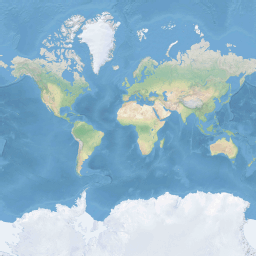
地図の取得と表示のパフォーマンスを最適化するため、地図は正方形のタイルに分割されています。 Azure Maps SDK では、道路地図にはサイズが 512 x 512 ピクセルのタイルが使われ、衛星画像にはそれより小さい 256 x 256 ピクセルが使われます。 Azure Maps では、23 のズーム レベル (0 から 22 までの番号が付けられている) に対してラスターおよびベクターのタイルが提供されます。 ズーム レベルが 0 の場合は、世界地図が 1 つのタイルに表示されます。
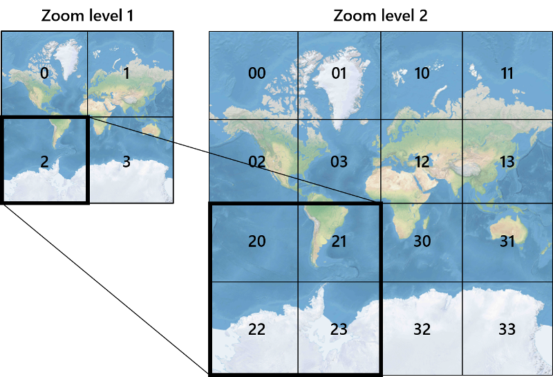
ズーム レベル 1 では、4 つのタイル (2 × 2 個の正方形) を使用して世界地図がレンダリングされます
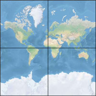
ズーム レベルを 1 つ追加するごとに、タイルが 4 分割され、2ズーム x 2ズーム 個のグリッドが作成されます。 ズーム レベル 22 の場合、グリッドは 222 x 222 となり、4,194,304 x 4,194,304 個のタイル (合計 17,592,186,044,416 個のタイル) になります。
Web および Android 用の Azure Maps 対話型コントロールでは、25 のズーム レベル (0 から 24 までの番号が付けられている) がサポートされます。 ただし、道路データをズーム レベルで使用できるのは、タイルが使用可能な場合のみです。
次の表では、タイルのサイズが 256 ピクセルの正方形であるズーム レベルに対する値の完全な一覧を示します。
| ズーム レベル | メートル/ピクセル | メートル/タイル一辺 |
|---|---|---|
| 0 | 156543 | 40075017 |
| 1 | 78271.5 | 20037508 |
| 2 | 39135.8 | 10018754 |
| 3 | 19567.88 | 5009377.1 |
| 4 | 9783.94 | 2504688.5 |
| 5 | 4891.97 | 1252344.3 |
| 6 | 2445.98 | 626172.1 |
| 7 | 1222.99 | 313086.1 |
| 8 | 611.5 | 156543 |
| 9 | 305.75 | 78271.5 |
| 10 | 152.87 | 39135.8 |
| 11 | 76.44 | 19567.9 |
| 12 | 38.219 | 9783.94 |
| 13 | 19.109 | 4891.97 |
| 14 | 9.555 | 2445.98 |
| 15 | 4.777 | 1222.99 |
| 16 | 2.3887 | 611.496 |
| 17 | 1.1943 | 305.748 |
| 18 | 0.5972 | 152.874 |
| 19 | 0.2986 | 76.437 |
| 20 | 0.14929 | 38.2185 |
| 21 | 0.074646 | 19.10926 |
| 22 | 0.037323 | 9.55463 |
| 23 | 0.0186615 | 4.777315 |
| 24 | 0.00933075 | 2.3886575 |
ピクセル座標
各ズーム レベルで使用する図法とスケールを選択したら、地理座標をピクセル座標に変換できます。 特定のズーム レベルに対する世界地図画像の完全なピクセルの幅と高さは、次のように計算します。
var mapWidth = tileSize * Math.pow(2, zoom);

var mapHeight = mapWidth;
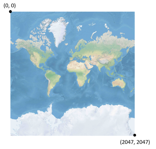
地図の幅と高さはズーム レベルによって異なるため、ピクセル座標もそうです。 地図の左上隅にあるピクセルは、常にピクセル座標が (0, 0) です。 地図の右下隅にあるピクセルのピクセル座標は (width-1, height-1)、または前のセクションの式を参照すると (tileSize 2zoom–1, tileSize * 2zoom–1) になります。 たとえば、レベル 2 で 512 の正方形のタイルを使用する場合、ピクセル座標は次のように (0, 0) から (2047, 2047) の範囲になります。
緯度と経度の値、および詳細レベルを指定すると、ピクセル XY 座標は次のように計算されます。
var sinLatitude = Math.sin(latitude * Math.PI/180);

var pixelX = ((longitude + 180) / 360) * tileSize * Math.pow(2, zoom);

var pixelY = (0.5 – Math.log((1 + sinLatitude) / (1 – sinLatitude)) / (4 * Math.PI)) * tileSize * Math.pow(2, zoom);
緯度と経度の値は、WGS 84 測地系と見なされます。 Azure Maps では球面投影が使用されますが、すべての地理的座標を共通の測地系に変換することが重要です。 選択した測地系は WGS 84 です。 経度の値は -180 度から +180 度の範囲と想定され、緯度の値は -85.05112878 から 85.05112878 の範囲にクリップされる必要があります。 これらの値に従うことで、両極の特異点が回避されるため、投影された地図が四角形になります。
タイルの座標
地図の取得と表示のパフォーマンスを最適化するため、レンダリングされる地図はタイルに分割されています。 ピクセル数とタイル数は、各ズーム レベルで異なります。
var numberOfTilesWide = Math.pow(2, zoom);

var numberOfTilesHigh = numberOfTilesWide;
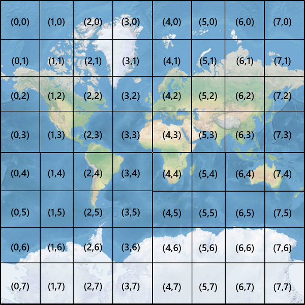
各タイルには、左上の (0, 0) から右下の (2zoom–1, 2zoom–1) の範囲の XY 座標が与えられます。 たとえば、ズーム レベル 3 の場合、タイルの座標は次のように (0, 0) から (7, 7) までの範囲になります。
ピクセル XY 座標のペアを指定すると、そのピクセルを含むタイルの XY 座標を簡単に特定できます。
var tileX = Math.floor(pixelX / tileSize);

var tileY = Math.floor(pixelY / tileSize);
タイルは、ズーム レベルによって呼び出されます。 X 座標と Y 座標は、そのズーム レベルのグリッド上のタイルの位置に対応します。
使用するズーム レベルを決定する際は、それぞれの場所が、そのタイル上の固定された位置に配置されるということに注意してください。 つまり、特定の区域を表示するために必要なタイル数は、ズーム グリッドが世界地図上のどこに配置されるかによって左右されます。 たとえば、互いに 900 メートル離れた 2 つの地点がある場合、ズーム レベル 17 では、それらの地点間のルートを 3 つのタイルで表示できる場合もありますが、 西側の地点がタイルの右寄りにあり、東側の地点がタイルの左寄りにある場合は、タイルが 4 個必要になる可能性もあります。
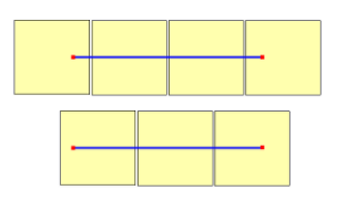
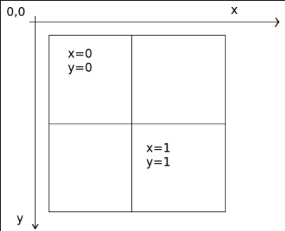
ズーム レベルが決定したら、x と y の値を計算できます。 各ズーム グリッドの左上隅のタイルは x=0, y=0 となり、右下隅のタイルは x=2zoom-1, y=2zoom-1 となります。
次に示すのは、ズーム レベル 1 のズーム グリッドです:
quadkey インデックス
一部のマッピング プラットフォームでは、quadkey インデックスの名前付け規則が使用されます。これは、タイルの ZY 座標を quadtree key または省略して quadkeys と呼ばれる 1 次元の文字列に結合したものです。 各 quadkey では、特定の詳細レベルの 1 つのタイルが一意に識別され、共通データベースの B ツリー インデックスのキーとして使用できます。 Azure Maps SDK では、タイル レイヤーの追加に関するドキュメントに記載されているように、他の命名規則に加えて、quadkey 名前付け規則を使用するタイル レイヤーのオーバーレイがサポートされています。
Note
quadkeys 名前付け規則は、1 以上のズーム レベルに対してのみ機能します。 Azure Maps SDK のサポート ズーム レベル 0 は、世界全体が 1 つのマップ タイルになります。
タイル座標を quadkey に変換するには、Y 座標と X 座標のビット数を交互に配置し、結果を底が 4 の数値として解釈して (先頭のゼロを維持)、文字列に変換します。 たとえば、レベル 3 のタイルの XY 座標が (3, 5) であるとすると、quadkey は次のように決定されます。
tileX = 3 = 011 (base 2)

tileY = 5 = 101 (base 2)

quadkey = 100111 (base 2) = 213 (base 4) = "213"
Qquadkeys には、興味深い特徴がいくつかあります。 1 つ目として、quadkey の長さ (桁数) は、対応するタイルのズーム レベルと同じになります。 2 つ目として、任意のタイルの quadkey は、その親タイルの quadkey (前のレベルで、それを含むタイル) で開始されます。 次の例で示すように、タイル 2 はタイル 20 から 23 の親です:
最後に、quadkeys では、通常は XY 空間内のタイルの近接性が保持される 1 次元のインデックス キーが提供されます。 言い換えると、XY 座標が近い 2 つのタイルは、通常、quadkeys も比較的近くなります。 これは、隣接するタイルがグループで要求されることが多く、ディスクの読み取り回数を最小限に抑えるには、これらのタイルを同じディスク ブロックに保持することが望ましいため、データベースのパフォーマンスを最適化するために重要なことです。
タイル演算のソース コード
次のサンプル コードでは、このドキュメントで説明されている関数を実装する方法が示されています。 これらの関数は、必要に応じて、他のプログラミング言語に簡単に変換できます。
using System;
using System.Text;

namespace AzureMaps
{
    /// <summary>
    /// Tile System math for the Spherical Mercator projection coordinate system (EPSG:3857)
    /// </summary>
    public static class TileMath
    {
        //Earth radius in meters.
        private const double EarthRadius = 6378137;

        private const double MinLatitude = -85.05112878;
        private const double MaxLatitude = 85.05112878;
        private const double MinLongitude = -180;
        private const double MaxLongitude = 180;

        /// <summary>
        /// Clips a number to the specified minimum and maximum values.
        /// </summary>
        /// <param name="n">The number to clip.</param>
        /// <param name="minValue">Minimum allowable value.</param>
        /// <param name="maxValue">Maximum allowable value.</param>
        /// <returns>The clipped value.</returns>
        private static double Clip(double n, double minValue, double maxValue)
        {
            return Math.Min(Math.Max(n, minValue), maxValue);
        }

        /// <summary>
        /// Calculates width and height of the map in pixels at a specific zoom level from -180 degrees to 180 degrees.
        /// </summary>
        /// <param name="zoom">Zoom Level to calculate width at</param>
        /// <param name="tileSize">The size of the tiles in the tile pyramid.</param>
        /// <returns>Width and height of the map in pixels</returns>
        public static double MapSize(double zoom, int tileSize)
        {
            return Math.Ceiling(tileSize * Math.Pow(2, zoom));
        }

        /// <summary>
        /// Calculates the Ground resolution at a specific degree of latitude in meters per pixel.
        /// </summary>
        /// <param name="latitude">Degree of latitude to calculate resolution at</param>
        /// <param name="zoom">Zoom level to calculate resolution at</param>
        /// <param name="tileSize">The size of the tiles in the tile pyramid.</param>
        /// <returns>Ground resolution in meters per pixels</returns>
        public static double GroundResolution(double latitude, double zoom, int tileSize)
        {
            latitude = Clip(latitude, MinLatitude, MaxLatitude);
            return Math.Cos(latitude * Math.PI / 180) * 2 * Math.PI * EarthRadius / MapSize(zoom, tileSize);
        }

        /// <summary>
        /// Determines the map scale at a specified latitude, level of detail, and screen resolution.
        /// </summary>
        /// <param name="latitude">Latitude (in degrees) at which to measure the map scale.</param>
        /// <param name="zoom">Level of detail, from 1 (lowest detail) to 23 (highest detail).</param>
        /// <param name="screenDpi">Resolution of the screen, in dots per inch.</param>
        /// <param name="tileSize">The size of the tiles in the tile pyramid.</param>
        /// <returns>The map scale, expressed as the denominator N of the ratio 1 : N.</returns>
        public static double MapScale(double latitude, double zoom, int screenDpi, int tileSize)
        {
            return GroundResolution(latitude, zoom, tileSize) * screenDpi / 0.0254;
        }

        /// <summary>
        /// Global Converts a Pixel coordinate into a geospatial coordinate at a specified zoom level.
        /// Global Pixel coordinates are relative to the top left corner of the map (90, -180)
        /// </summary>
        /// <param name="pixel">Pixel coordinates in the format of [x, y].</param>
        /// <param name="zoom">Zoom level</param>
        /// <param name="tileSize">The size of the tiles in the tile pyramid.</param>
        /// <returns>A position value in the format [longitude, latitude].</returns>
        public static double[] GlobalPixelToPosition(double[] pixel, double zoom, int tileSize)
        {
            var mapSize = MapSize(zoom, tileSize);

            var x = (Clip(pixel[0], 0, mapSize - 1) / mapSize) - 0.5;
            var y = 0.5 - (Clip(pixel[1], 0, mapSize - 1) / mapSize);

            return new double[] {
                360 * x,    //Longitude
                90 - 360 * Math.Atan(Math.Exp(-y * 2 * Math.PI)) / Math.PI  //Latitude
            };
        }

        /// <summary>
        /// Converts a point from latitude/longitude WGS-84 coordinates (in degrees) into pixel XY coordinates at a specified level of detail.
        /// </summary>
        /// <param name="position">Position coordinate in the format [longitude, latitude]</param>
        /// <param name="zoom">Zoom level.</param>
        /// <param name="tileSize">The size of the tiles in the tile pyramid.</param>
        /// <returns>A global pixel coordinate.</returns>
        public static double[] PositionToGlobalPixel(double[] position, int zoom, int tileSize)
        {
            var latitude = Clip(position[1], MinLatitude, MaxLatitude);
            var longitude = Clip(position[0], MinLongitude, MaxLongitude);

            var x = (longitude + 180) / 360;
            var sinLatitude = Math.Sin(latitude * Math.PI / 180);
            var y = 0.5 - Math.Log((1 + sinLatitude) / (1 - sinLatitude)) / (4 * Math.PI);

            var mapSize = MapSize(zoom, tileSize);

            return new double[] {
                 Clip(x * mapSize + 0.5, 0, mapSize - 1),
                 Clip(y * mapSize + 0.5, 0, mapSize - 1)
            };
        }

        /// <summary>
        /// Converts pixel XY coordinates into tile XY coordinates of the tile containing the specified pixel.
        /// </summary>
        /// <param name="pixel">Pixel coordinates in the format of [x, y].</param>
        /// <param name="tileSize">The size of the tiles in the tile pyramid.</param>
        /// <param name="tileX">Output parameter receiving the tile X coordinate.</param>
        /// <param name="tileY">Output parameter receiving the tile Y coordinate.</param>
        public static void GlobalPixelToTileXY(double[] pixel, int tileSize, out int tileX, out int tileY)
        {
            tileX = (int)(pixel[0] / tileSize);
            tileY = (int)(pixel[1] / tileSize);
        }

        /// <summary>
        /// Performs a scale transform on a global pixel value from one zoom level to another.
        /// </summary>
        /// <param name="pixel">Pixel coordinates in the format of [x, y].</param>
        /// <param name="oldZoom">The zoom level in which the input global pixel value is from.</param>
        /// <returns>A scale pixel coordinate.</returns>
        public static double[] ScaleGlobalPixel(double[] pixel, double oldZoom, double newZoom)
        {
            var scale = Math.Pow(2, oldZoom - newZoom);

            return new double[] { pixel[0] * scale, pixel[1] * scale };
        }

        /// <summary>
        /// Performs a scale transform on a set of global pixel values from one zoom level to another.
        /// </summary>
        /// <param name="pixels">A set of global pixel value from the old zoom level. Points are in the format [x,y].</param>
        /// <param name="oldZoom">The zoom level in which the input global pixel values is from.</param>
        /// <param name="newZoom">The new zoom level in which the output global pixel values should be aligned with.</param>
        /// <returns>A set of global pixel values that has been scaled for the new zoom level.</returns>
        public static double[][] ScaleGlobalPixels(double[][] pixels, double oldZoom, double newZoom)
        {
            var scale = Math.Pow(2, oldZoom - newZoom);

            var output = new System.Collections.Generic.List<double[]>();
            foreach (var p in pixels)
            {
                output.Add(new double[] { p[0] * scale, p[1] * scale });
            }

            return output.ToArray();
        }

        /// <summary>
        /// Converts tile XY coordinates into a global pixel XY coordinates of the upper-left pixel of the specified tile.
        /// </summary>
        /// <param name="tileX">Tile X coordinate.</param>
        /// <param name="tileY">Tile Y coordinate.</param>
        /// <param name="tileSize">The size of the tiles in the tile pyramid.</param>
        /// <param name="pixelX">Output parameter receiving the X coordinate of the point, in pixels.</param>
        /// <param name="pixelY">Output parameter receiving the Y coordinate of the point, in pixels.</param>
        public static double[] TileXYToGlobalPixel(int tileX, int tileY, int tileSize)
        {
            return new double[] { tileX * tileSize, tileY * tileSize };
        }

        /// <summary>
        /// Converts tile XY coordinates into a quadkey at a specified level of detail.
        /// </summary>
        /// <param name="tileX">Tile X coordinate.</param>
        /// <param name="tileY">Tile Y coordinate.</param>
        /// <param name="zoom">Zoom level</param>
        /// <returns>A string containing the quadkey.</returns>
        public static string TileXYToQuadKey(int tileX, int tileY, int zoom)
        {
            var quadKey = new StringBuilder();
            for (int i = zoom; i > 0; i--)
            {
                char digit = '0';
                int mask = 1 << (i - 1);
                if ((tileX & mask) != 0)
                {
                    digit++;
                }
                if ((tileY & mask) != 0)
                {
                    digit++;
                    digit++;
                }
                quadKey.Append(digit);
            }
            return quadKey.ToString();
        }

        /// <summary>
        /// Converts a quadkey into tile XY coordinates.
        /// </summary>
        /// <param name="quadKey">Quadkey of the tile.</param>
        /// <param name="tileX">Output parameter receiving the tile X coordinate.</param>
        /// <param name="tileY">Output parameter receiving the tile Y coordinate.</param>
        /// <param name="zoom">Output parameter receiving the zoom level.</param>
        public static void QuadKeyToTileXY(string quadKey, out int tileX, out int tileY, out int zoom)
        {
            tileX = tileY = 0;
            zoom = quadKey.Length;
            for (int i = zoom; i > 0; i--)
            {
                int mask = 1 << (i - 1);
                switch (quadKey[zoom - i])
                {
                    case '0':
                        break;

                    case '1':
                        tileX |= mask;
                        break;

                    case '2':
                        tileY |= mask;
                        break;

                    case '3':
                        tileX |= mask;
                        tileY |= mask;
                        break;

                    default:
                        throw new ArgumentException("Invalid QuadKey digit sequence.");
                }
            }
        }

        /// <summary>
        /// Calculates the XY tile coordinates that a coordinate falls into for a specific zoom level.
        /// </summary>
        /// <param name="position">Position coordinate in the format [longitude, latitude]</param>
        /// <param name="zoom">Zoom level</param>
        /// <param name="tileSize">The size of the tiles in the tile pyramid.</param>
        /// <param name="tileX">Output parameter receiving the tile X position.</param>
        /// <param name="tileY">Output parameter receiving the tile Y position.</param>
        public static void PositionToTileXY(double[] position, int zoom, int tileSize, out int tileX, out int tileY)
        {
            var latitude = Clip(position[1], MinLatitude, MaxLatitude);
            var longitude = Clip(position[0], MinLongitude, MaxLongitude);

            var x = (longitude + 180) / 360;
            var sinLatitude = Math.Sin(latitude * Math.PI / 180);
            var y = 0.5 - Math.Log((1 + sinLatitude) / (1 - sinLatitude)) / (4 * Math.PI);

            //tileSize needed in calculations as in rare cases the multiplying/rounding/dividing can make the difference of a pixel which can result in a completely different tile.
            var mapSize = MapSize(zoom, tileSize);
            tileX = (int)Math.Floor(Clip(x * mapSize + 0.5, 0, mapSize - 1) / tileSize);
            tileY = (int)Math.Floor(Clip(y * mapSize + 0.5, 0, mapSize - 1) / tileSize);
        }

        /// <summary>
        /// Calculates the tile quadkey strings that are within a specified viewport.
        /// </summary>
        /// <param name="position">Position coordinate in the format [longitude, latitude]</param>
        /// <param name="zoom">Zoom level</param>
        /// <param name="width">The width of the map viewport in pixels.</param>
        /// <param name="height">The height of the map viewport in pixels.</param>
        /// <param name="tileSize">The size of the tiles in the tile pyramid.</param>
        /// <returns>A list of quadkey strings that are within the specified viewport.</returns>
        public static string[] GetQuadkeysInView(double[] position, int zoom, int width, int height, int tileSize)
        {
            var p = PositionToGlobalPixel(position, zoom, tileSize);

            var top = p[1] - height * 0.5;
            var left = p[0] - width * 0.5;

            var bottom = p[1] + height * 0.5;
            var right = p[0] + width * 0.5;

            var tl = GlobalPixelToPosition(new double[] { left, top }, zoom, tileSize);
            var br = GlobalPixelToPosition(new double[] { right, bottom }, zoom, tileSize);

            //Boudning box in the format: [west, south, east, north];
            var bounds = new double[] { tl[0], br[1], br[0], tl[1] };

            return GetQuadkeysInBoundingBox(bounds, zoom, tileSize);
        }

        /// <summary>
        /// Calculates the tile quadkey strings that are within a bounding box at a specific zoom level.
        /// </summary>
        /// <param name="bounds">A bounding box defined as an array of numbers in the format of [west, south, east, north].</param>
        /// <param name="zoom">Zoom level to calculate tiles for.</param>
        /// <param name="tileSize">The size of the tiles in the tile pyramid.</param>
        /// <returns>A list of quadkey strings.</returns>
        public static string[] GetQuadkeysInBoundingBox(double[] bounds, int zoom, int tileSize)
        {
            var keys = new System.Collections.Generic.List<string>();

            if (bounds != null && bounds.Length >= 4)
            {
                PositionToTileXY(new double[] { bounds[3], bounds[0] }, zoom, tileSize, out int tlX, out int tlY);
                PositionToTileXY(new double[] { bounds[1], bounds[2] }, zoom, tileSize, out int brX, out int brY);

                for (int x = tlX; x <= brX; x++)
                {
                    for (int y = tlY; y <= brY; y++)
                    {
                        keys.Add(TileXYToQuadKey(x, y, zoom));
                    }
                }
            }

            return keys.ToArray();
        }

        /// <summary>
        /// Calculates the bounding box of a tile.
        /// </summary>
        /// <param name="tileX">Tile X coordinate</param>
        /// <param name="tileY">Tile Y coordinate</param>
        /// <param name="zoom">Zoom level</param>
        /// <param name="tileSize">The size of the tiles in the tile pyramid.</param>
        /// <returns>A bounding box of the tile defined as an array of numbers in the format of [west, south, east, north].</returns>
        public static double[] TileXYToBoundingBox(int tileX, int tileY, double zoom, int tileSize)
        {
            //Top left corner pixel coordinates
            var x1 = (double)(tileX * tileSize);
            var y1 = (double)(tileY * tileSize);

            //Bottom right corner pixel coordinates
            var x2 = (double)(x1 + tileSize);
            var y2 = (double)(y1 + tileSize);

            var nw = GlobalPixelToPosition(new double[] { x1, y1 }, zoom, tileSize);
            var se = GlobalPixelToPosition(new double[] { x2, y2 }, zoom, tileSize);

            return new double[] { nw[0], se[1], se[0], nw[1] };
        }

        /// <summary>
        /// Calculates the best map view (center, zoom) for a bounding box on a map.
        /// </summary>
        /// <param name="bounds">A bounding box defined as an array of numbers in the format of [west, south, east, north].</param>
        /// <param name="mapWidth">Map width in pixels.</param>
        /// <param name="mapHeight">Map height in pixels.</param>
        /// <param name="padding">Width in pixels to use to create a buffer around the map. This is to keep markers from being cut off on the edge</param>
        /// <param name="tileSize">The size of the tiles in the tile pyramid.</param>
        /// <param name="latitude">Output parameter receiving the center latitude coordinate.</param>
        /// <param name="longitude">Output parameter receiving the center longitude coordinate.</param>
        /// <param name="zoom">Output parameter receiving the zoom level</param>
        public static void BestMapView(double[] bounds, double mapWidth, double mapHeight, int padding, int tileSize, out double centerLat, out double centerLon, out double zoom)
        {
            if (bounds == null || bounds.Length < 4)
            {
                centerLat = 0;
                centerLon = 0;
                zoom = 1;
                return;
            }

            double boundsDeltaX;

            //Check if east value is greater than west value which would indicate that bounding box crosses the antimeridian.
            if (bounds[2] > bounds[0])
            {
                boundsDeltaX = bounds[2] - bounds[0];
                centerLon = (bounds[2] + bounds[0]) / 2;
            }
            else
            {
                boundsDeltaX = 360 - (bounds[0] - bounds[2]);
                centerLon = ((bounds[2] + bounds[0]) / 2 + 360) % 360 - 180;
            }

            var ry1 = Math.Log((Math.Sin(bounds[1] * Math.PI / 180) + 1) / Math.Cos(bounds[1] * Math.PI / 180));
            var ry2 = Math.Log((Math.Sin(bounds[3] * Math.PI / 180) + 1) / Math.Cos(bounds[3] * Math.PI / 180));
            var ryc = (ry1 + ry2) / 2;

            centerLat = Math.Atan(Math.Sinh(ryc)) * 180 / Math.PI;

            var resolutionHorizontal = boundsDeltaX / (mapWidth - padding * 2);

            var vy0 = Math.Log(Math.Tan(Math.PI * (0.25 + centerLat / 360)));
            var vy1 = Math.Log(Math.Tan(Math.PI * (0.25 + bounds[3] / 360)));
            var zoomFactorPowered = (mapHeight * 0.5 - padding) / (40.7436654315252 * (vy1 - vy0));
            var resolutionVertical = 360.0 / (zoomFactorPowered * tileSize);

            var resolution = Math.Max(resolutionHorizontal, resolutionVertical);

            zoom = Math.Log(360 / (resolution * tileSize), 2);
        }
    }
}
Note
Azure Maps SDK の対話型マップ コントロールには、地理空間位置とビューポートのピクセルの間で変換を行うためのヘルパー関数が用意されています。
次のステップ
Azure Maps REST サービスから地図のタイルに直接アクセスします。
地理空間の概念について詳しくは、次をご覧ください。