geo_point_to_geohash()
地理的な場所の geohash 文字列値を計算します。
geohash に関する詳細をお読みください。
構文
geo_point_to_geohash(経度,緯度,[ accuracy ])
構文規則について詳しく知る。
パラメーター
| 名前 | 型 | 必須 | 説明 |
|---|---|---|---|
| longitude | real |
✔️ | 地理空間座標、経度値 (度単位)。 有効な値は実数で、[-180, +180] の範囲です。 |
| latitude | real |
✔️ | 地理空間座標、緯度の値 (度単位)。 有効な値は実数で、[-90, +90] の範囲です。 |
| 精度 | int |
要求された精度を定義します。 サポートされている値の範囲は [1, 18] です。 指定されない場合は、既定値の 5 が使用されます。 |
戻り値
要求された精度の長さを持つ、特定の地理的な場所の geohash 文字列値。 座標または精度が無効な場合、クエリは空の結果を生成します。
Note
- Geohash は、便利な地理空間クラスタリング ツールです。
- Geohash には、18 の精度レベルがあり、適用範囲は最高レベル 1 の 2500万 km²から最低レベル 18 の 0.6μ² です。
- geohash の一般的なプレフィックスは、互いにポイントの近接性を示します。 共有プレフィックスが長いほど、2 つの場所が近いということになります。 精度の値は、geohash の長さに変換されます。
- geohash は、平面上の四角形の領域です。
- 経度 x と緯度 y で 計算された geohash 文字列に対して geo_geohash_to_central_point() 関数を呼び出しても、必ずしも x と y が返されるとは限りません。
- geohash 定義により、2 つの地理的な場所が互いに非常に近いが、異なる geohash コードを持つ可能性があります。
精度値ごとの geohash 四角形の適用範囲:
| 精度 | 幅 | [高さ] |
|---|---|---|
| 1 | 5000 km | 5000 km |
| 2 | 1250 km | 625 km |
| 3 | 156.25 km | 156.25 km |
| 4 | 39.06 km | 19.53 km |
| 5 | 4.88 km | 4.88 km |
| 6 | 1.22 km | 0.61 km |
| 7 | 152.59 m | 152.59 m |
| 8 | 38.15 m | 19.07 m |
| 9 | 4.77 m | 4.77 m |
| 10 | 1.19 m | 0.59 m |
| 11 | 149.01 mm | 149.01 mm |
| 12 | 37.25 mm | 18.63 mm |
| 13 | 4.66 mm | 4.66 mm |
| 14 | 1.16 mm | 0.58 mm |
| 15 | 145.52 μ | 145.52 μ |
| 16 | 36.28 μ | 18.19 μ |
| 17 | 4.55 μ | 4.55 μ |
| 18 | 1.14 μ | 0.57 μ |
geo_point_to_s2cell()、geo_point_to_h3cell() も参照してください。
使用可能な他のグリッド システムとの比較については、「 Kusto クエリ言語を使用した地理空間クラスタリング」を参照してください。
例
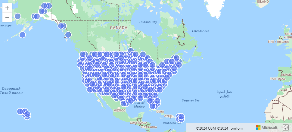
次の例では、geohash によって集計された US Storm イベントを検索します。
StormEvents
| project BeginLon, BeginLat
| summarize by hash=geo_point_to_geohash(BeginLon, BeginLat, 3)
| project geo_geohash_to_central_point(hash)
| render scatterchart with (kind=map)
出力
次の例では、geohash 文字列値を計算して返します。
print geohash = geo_point_to_geohash(-80.195829, 25.802215, 8)
出力
| geohash |
|---|
| dhwfz15h |
次の例では、座標のグループを検索します。 グループ内のすべての座標ペアは、4.88 km x 4.88 km の四角形領域に存在します。
datatable(location_id:string, longitude:real, latitude:real)
[
  "A", double(-122.303404), 47.570482,
  "B", double(-122.304745), 47.567052,
  "C", double(-122.278156), 47.566936,
]
| summarize count = count(),                                          // items per group count
            locations = make_list(location_id)                        // items in the group
            by geohash = geo_point_to_geohash(longitude, latitude)    // geohash of the group
出力
| geohash | count | locations |
|---|---|---|
| c23n8 | 2 | ["A", "B"] |
| c23n9 | 1 | ["C"] |
次の例では、座標入力が無効であるため、空の結果が生成されます。
print geohash = geo_point_to_geohash(200,1,8)
出力
| geohash |
|---|
次の例では、精度入力が無効であるため、空の結果が生成されます。
print geohash = geo_point_to_geohash(1,1,int(null))
出力
| geohash |
|---|
フィードバック
以下は間もなく提供いたします。2024 年を通じて、コンテンツのフィードバック メカニズムとして GitHub の issue を段階的に廃止し、新しいフィードバック システムに置き換えます。 詳細については、「https://aka.ms/ContentUserFeedback」を参照してください。
フィードバックの送信と表示