你当前正在访问 Microsoft Azure Global Edition 技术文档网站。 如果需要访问由世纪互联运营的 Microsoft Azure 中国技术文档网站,请访问 https://docs.azure.cn。
缩放级别和磁贴网格
Azure Maps 使用球面 Mercator 投影坐标系统 (EPSG:3857)。 投影是用于将地球球体转换为平面地图的数学模型。 球面墨卡托投影在两极处拉伸地图,以创建正方形地图。 此投影会明显扭曲地图的比例和面积,但相比此扭曲,有两个关键属性更重要:
- 它是一种保形投影,这意味着它将保留相对较小的对象的形状。 在显示航拍图像时,保留较小对象的形状尤其重要。 例如,我们希望避免扭曲建筑物的形状。 正方形建筑应显示为正方形,而不是矩形。
- 它是一种柱面投影。 北部和南部始终是上和下,而西部和东部始终是左和右。
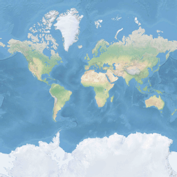
为了优化地图的检索和显示性能,地图分成了正方形图块。 对于道路地图,Azure Maps SDK 使用大小为 512 x 512 像素的图块,对于卫星图像使用较小的 256 x 256 像素。 Azure Maps 提供 23 个缩放级别(编号为 0 到 22)的光栅图块和矢量图块。 在缩放级别为 0 时,单个磁贴可以容纳整个世界:
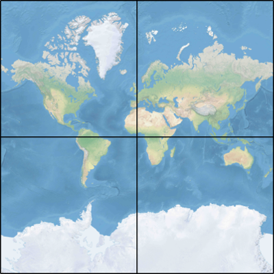
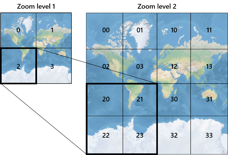
缩放级别 1 使用 4 个磁贴来呈现世界:一个 2 x 2 的正方形
每个递增的缩放级别都将前一个缩放级别的图块分为四份,从而创建一个 2 zoom x 2 zoom 的网格。 缩放级别 22 是一个 222 x 222 的网格,或有 4,194,304 x 4,194,304 个磁贴(共有 17,592,186,044,416 个磁贴)。
适用于 Web 和 Android 的 Azure Maps 交互式地图控件支持 25 个缩放级别,其编号为 0 到 24。 但是只有当图块可用时,才会提供缩放级别的道路数据。
下表提供了缩放级别的值的完整列表,其中的图块大小为 256x256 像素:
| 缩放级别 | 计量/像素 | 计量/磁贴边 |
|---|---|---|
| 0 | 156543 | 40075017 |
| 1 | 78271.5 | 20037508 |
| 2 | 39135.8 | 10018754 |
| 3 | 19567.88 | 5009377.1 |
| 4 | 9783.94 | 2504688.5 |
| 5 | 4891.97 | 1252344.3 |
| 6 | 2445.98 | 626172.1 |
| 7 | 1222.99 | 313086.1 |
| 8 | 611.5 | 156543 |
| 9 | 305.75 | 78271.5 |
| 10 | 152.87 | 39135.8 |
| 11 | 76.44 | 19567.9 |
| 12 | 38.219 | 9783.94 |
| 13 | 19.109 | 4891.97 |
| 14 | 9.555 | 2445.98 |
| 15 | 4.777 | 1222.99 |
| 16 | 2.3887 | 611.496 |
| 17 | 1.1943 | 305.748 |
| 18 | 0.5972 | 152.874 |
| 19 | 0.2986 | 76.437 |
| 20 | 0.14929 | 38.2185 |
| 21 | 0.074646 | 19.10926 |
| 22 | 0.037323 | 9.55463 |
| 23 | 0.0186615 | 4.777315 |
| 24 | 0.00933075 | 2.3886575 |
像素坐标
选择要在每个缩放级别使用的投影和比例后,可以将地理坐标转换为像素坐标。 按以下方式计算特定缩放级别的世界地图图像的完整像素宽度和高度:
var mapWidth = tileSize * Math.pow(2, zoom);

var mapHeight = mapWidth;
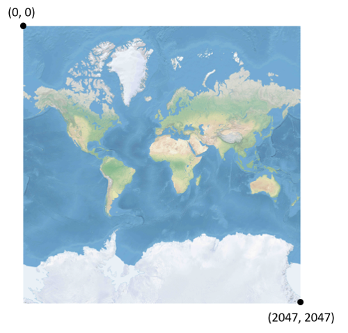
由于每个缩放级别的地图宽度和高度都不同,因此像素坐标也不相同。 地图左上角的像素的像素坐标始终为 (0, 0)。 地图右下角的像素的像素坐标为 (宽度-1, 高度-1);或参照上一部分中的方程式:(tileSize * 2zoom–1, tileSize * 2zoom–1)。 例如,在级别 2 使用 512 x 512 图块时,像素坐标的范围为 (0, 0) 到 (2047, 2047),如下所示:
给定纬度和经度(以度为单位)和详细级别时,按以下方式计算像素 XY 坐标:
var sinLatitude = Math.sin(latitude * Math.PI/180);

var pixelX = ((longitude + 180) / 360) * tileSize * Math.pow(2, zoom);

var pixelY = (0.5 – Math.log((1 + sinLatitude) / (1 – sinLatitude)) / (4 * Math.PI)) * tileSize * Math.pow(2, zoom);
纬度值和经度值假定在 WGS 84 基准上。 即使 Azure Maps 使用球面投影,也务必将所有地理坐标转换为普通基准。 WGS 84 是所选的基准。 假定经度值的范围为 -180 度到 + 180 度,并且纬度值的范围必须裁剪为 -85.05112878 到 85.05112878。 采用这些值可避免两极处出现奇点,并确保投影地图为正方形。
图块坐标
为优化地图的检索和显示性能,呈现的地图会分割为图块。 每个缩放级别的像素数和图块数都不同:
var numberOfTilesWide = Math.pow(2, zoom);

var numberOfTilesHigh = numberOfTilesWide;
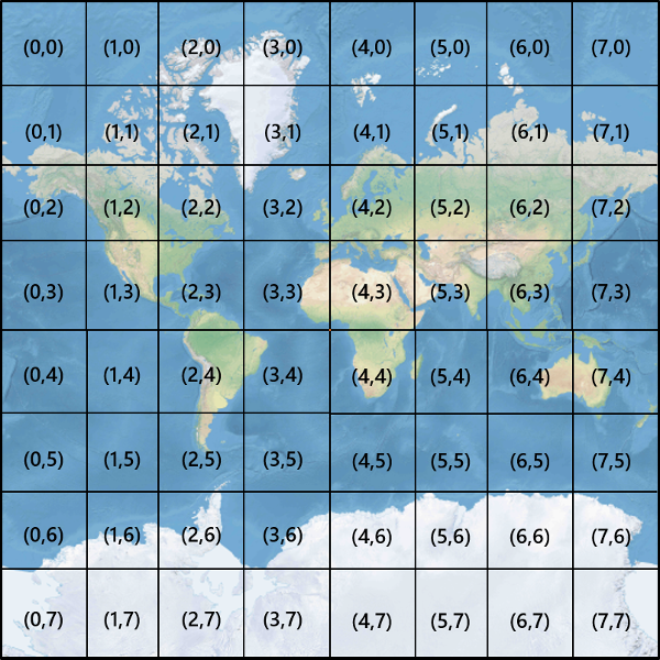
每个图块都具有 XY 坐标,坐标范围为 (0, 0)(左上角)到 (2zoom–1, 2zoom–1)(右下角)。 例如,在缩放级别 3 中,图块坐标的范围为 (0, 0) 到 (7, 7),如下所示:
给定一对像素 XY 坐标时,可以轻松确定包含该像素的图块的图块 XY 坐标:
var tileX = Math.floor(pixelX / tileSize);

var tileY = Math.floor(pixelY / tileSize);
图块按缩放级别调用。 x 和 y 坐标对应图块在该缩放级别的网格中的位置。
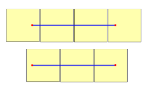
在确定要使用的缩放级别时,请记住每个位置在其图块上是固定的。 因此,要显示给定区域范围所需的图块数量取决于世界地图上缩放网格的具体位置。 例如,如果有两个点相距 900 米,则可能仅在缩放级别 17 使用三个磁贴来显示这两点之间的路线。 但是,如果西边的点在磁贴的右边,而东边的点在磁贴的左边,则需要四个磁贴:
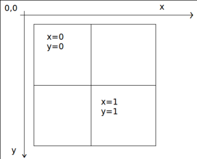
缩放级别确定后,可以计算 x 和 y 值。 每个缩放网格的左上方图块为 x=0, y=0,右下方图块为 x=2zoom-1, y=2zoom-1。
以下是缩放级别 1 的缩放网格:
Quadkey 索引
某些映射平台使用 quadkey 索引命名约定,该约定将图块 ZY 坐标合并为一维字符串(称为 quadtree 键,或简称为 quadkeys)。 每个 quadkey 唯一地标识特定详细级别的单个图块,并且它可用作常用数据库 B 树索引中的键。 Azure Maps SDK 支持覆盖使用 quadkey 命名约定的图块层,以及使用quadkey文档中介绍的其他命名约定的图块层。
注意
quadkeys 命名约定仅适用于级别 1 或更高的缩放级别。 Azure Maps SDK 支持缩放级别 0,此级别是表示整个世界的单个地图图块。
若要将图块坐标转换为 quadkey,要交错 Y 和 X 坐标的位,将结果表示为 base-4 数值(保留前导 0)并转换为字符串。 例如,给定级别 3 中的图块 XY 坐标 (3, 5),按以下方式确定 quadkey:
tileX = 3 = 011 (base 2)

tileY = 5 = 101 (base 2)

quadkey = 100111 (base 2) = 213 (base 4) = "213"
Qquadkeys 具有几个有趣的属性。 首先,quadkey 的长度(位数)等于相应图块的缩放级别。 其次,任何图块的 quadkey 都以其父图块(上一级别的包含图块)的 quadkey 开头。 如下例所示,图块 2 是图块 20 到23 的父图块:
最后,quadkeys 提供的一维索引键通常保留图块在 XY 空间中的邻近性。 换句话说,如果两个图块的 XY 坐标相邻,通常它们的 quadkeys 也相对接近。 这对于优化数据库性能至关重要,因为通常会按组请求相邻图块,因此最好将这些图块保存在相同的磁盘块上,以最大程度地减少磁盘读取次数。
图块数学源代码
下面的示例代码演示如何实现本文档中所述的函数。 可以根据需要轻松地将这些函数转换为其他编程语言。
using System;
using System.Text;

namespace AzureMaps
{
    /// <summary>
    /// Tile System math for the Spherical Mercator projection coordinate system (EPSG:3857)
    /// </summary>
    public static class TileMath
    {
        //Earth radius in meters.
        private const double EarthRadius = 6378137;

        private const double MinLatitude = -85.05112878;
        private const double MaxLatitude = 85.05112878;
        private const double MinLongitude = -180;
        private const double MaxLongitude = 180;

        /// <summary>
        /// Clips a number to the specified minimum and maximum values.
        /// </summary>
        /// <param name="n">The number to clip.</param>
        /// <param name="minValue">Minimum allowable value.</param>
        /// <param name="maxValue">Maximum allowable value.</param>
        /// <returns>The clipped value.</returns>
        private static double Clip(double n, double minValue, double maxValue)
        {
            return Math.Min(Math.Max(n, minValue), maxValue);
        }

        /// <summary>
        /// Calculates width and height of the map in pixels at a specific zoom level from -180 degrees to 180 degrees.
        /// </summary>
        /// <param name="zoom">Zoom Level to calculate width at</param>
        /// <param name="tileSize">The size of the tiles in the tile pyramid.</param>
        /// <returns>Width and height of the map in pixels</returns>
        public static double MapSize(double zoom, int tileSize)
        {
            return Math.Ceiling(tileSize * Math.Pow(2, zoom));
        }

        /// <summary>
        /// Calculates the Ground resolution at a specific degree of latitude in meters per pixel.
        /// </summary>
        /// <param name="latitude">Degree of latitude to calculate resolution at</param>
        /// <param name="zoom">Zoom level to calculate resolution at</param>
        /// <param name="tileSize">The size of the tiles in the tile pyramid.</param>
        /// <returns>Ground resolution in meters per pixels</returns>
        public static double GroundResolution(double latitude, double zoom, int tileSize)
        {
            latitude = Clip(latitude, MinLatitude, MaxLatitude);
            return Math.Cos(latitude * Math.PI / 180) * 2 * Math.PI * EarthRadius / MapSize(zoom, tileSize);
        }

        /// <summary>
        /// Determines the map scale at a specified latitude, level of detail, and screen resolution.
        /// </summary>
        /// <param name="latitude">Latitude (in degrees) at which to measure the map scale.</param>
        /// <param name="zoom">Level of detail, from 1 (lowest detail) to 23 (highest detail).</param>
        /// <param name="screenDpi">Resolution of the screen, in dots per inch.</param>
        /// <param name="tileSize">The size of the tiles in the tile pyramid.</param>
        /// <returns>The map scale, expressed as the denominator N of the ratio 1 : N.</returns>
        public static double MapScale(double latitude, double zoom, int screenDpi, int tileSize)
        {
            return GroundResolution(latitude, zoom, tileSize) * screenDpi / 0.0254;
        }

        /// <summary>
        /// Global Converts a Pixel coordinate into a geospatial coordinate at a specified zoom level.
        /// Global Pixel coordinates are relative to the top left corner of the map (90, -180)
        /// </summary>
        /// <param name="pixel">Pixel coordinates in the format of [x, y].</param>
        /// <param name="zoom">Zoom level</param>
        /// <param name="tileSize">The size of the tiles in the tile pyramid.</param>
        /// <returns>A position value in the format [longitude, latitude].</returns>
        public static double[] GlobalPixelToPosition(double[] pixel, double zoom, int tileSize)
        {
            var mapSize = MapSize(zoom, tileSize);

            var x = (Clip(pixel[0], 0, mapSize - 1) / mapSize) - 0.5;
            var y = 0.5 - (Clip(pixel[1], 0, mapSize - 1) / mapSize);

            return new double[] {
                360 * x,    //Longitude
                90 - 360 * Math.Atan(Math.Exp(-y * 2 * Math.PI)) / Math.PI  //Latitude
            };
        }

        /// <summary>
        /// Converts a point from latitude/longitude WGS-84 coordinates (in degrees) into pixel XY coordinates at a specified level of detail.
        /// </summary>
        /// <param name="position">Position coordinate in the format [longitude, latitude]</param>
        /// <param name="zoom">Zoom level.</param>
        /// <param name="tileSize">The size of the tiles in the tile pyramid.</param>
        /// <returns>A global pixel coordinate.</returns>
        public static double[] PositionToGlobalPixel(double[] position, int zoom, int tileSize)
        {
            var latitude = Clip(position[1], MinLatitude, MaxLatitude);
            var longitude = Clip(position[0], MinLongitude, MaxLongitude);

            var x = (longitude + 180) / 360;
            var sinLatitude = Math.Sin(latitude * Math.PI / 180);
            var y = 0.5 - Math.Log((1 + sinLatitude) / (1 - sinLatitude)) / (4 * Math.PI);

            var mapSize = MapSize(zoom, tileSize);

            return new double[] {
                 Clip(x * mapSize + 0.5, 0, mapSize - 1),
                 Clip(y * mapSize + 0.5, 0, mapSize - 1)
            };
        }

        /// <summary>
        /// Converts pixel XY coordinates into tile XY coordinates of the tile containing the specified pixel.
        /// </summary>
        /// <param name="pixel">Pixel coordinates in the format of [x, y].</param>
        /// <param name="tileSize">The size of the tiles in the tile pyramid.</param>
        /// <param name="tileX">Output parameter receiving the tile X coordinate.</param>
        /// <param name="tileY">Output parameter receiving the tile Y coordinate.</param>
        public static void GlobalPixelToTileXY(double[] pixel, int tileSize, out int tileX, out int tileY)
        {
            tileX = (int)(pixel[0] / tileSize);
            tileY = (int)(pixel[1] / tileSize);
        }

        /// <summary>
        /// Performs a scale transform on a global pixel value from one zoom level to another.
        /// </summary>
        /// <param name="pixel">Pixel coordinates in the format of [x, y].</param>
        /// <param name="oldZoom">The zoom level in which the input global pixel value is from.</param>
        /// <returns>A scale pixel coordinate.</returns>
        public static double[] ScaleGlobalPixel(double[] pixel, double oldZoom, double newZoom)
        {
            var scale = Math.Pow(2, oldZoom - newZoom);

            return new double[] { pixel[0] * scale, pixel[1] * scale };
        }

        /// <summary>
        /// Performs a scale transform on a set of global pixel values from one zoom level to another.
        /// </summary>
        /// <param name="pixels">A set of global pixel value from the old zoom level. Points are in the format [x,y].</param>
        /// <param name="oldZoom">The zoom level in which the input global pixel values is from.</param>
        /// <param name="newZoom">The new zoom level in which the output global pixel values should be aligned with.</param>
        /// <returns>A set of global pixel values that has been scaled for the new zoom level.</returns>
        public static double[][] ScaleGlobalPixels(double[][] pixels, double oldZoom, double newZoom)
        {
            var scale = Math.Pow(2, oldZoom - newZoom);

            var output = new System.Collections.Generic.List<double[]>();
            foreach (var p in pixels)
            {
                output.Add(new double[] { p[0] * scale, p[1] * scale });
            }

            return output.ToArray();
        }

        /// <summary>
        /// Converts tile XY coordinates into a global pixel XY coordinates of the upper-left pixel of the specified tile.
        /// </summary>
        /// <param name="tileX">Tile X coordinate.</param>
        /// <param name="tileY">Tile Y coordinate.</param>
        /// <param name="tileSize">The size of the tiles in the tile pyramid.</param>
        /// <param name="pixelX">Output parameter receiving the X coordinate of the point, in pixels.</param>
        /// <param name="pixelY">Output parameter receiving the Y coordinate of the point, in pixels.</param>
        public static double[] TileXYToGlobalPixel(int tileX, int tileY, int tileSize)
        {
            return new double[] { tileX * tileSize, tileY * tileSize };
        }

        /// <summary>
        /// Converts tile XY coordinates into a quadkey at a specified level of detail.
        /// </summary>
        /// <param name="tileX">Tile X coordinate.</param>
        /// <param name="tileY">Tile Y coordinate.</param>
        /// <param name="zoom">Zoom level</param>
        /// <returns>A string containing the quadkey.</returns>
        public static string TileXYToQuadKey(int tileX, int tileY, int zoom)
        {
            var quadKey = new StringBuilder();
            for (int i = zoom; i > 0; i--)
            {
                char digit = '0';
                int mask = 1 << (i - 1);
                if ((tileX & mask) != 0)
                {
                    digit++;
                }
                if ((tileY & mask) != 0)
                {
                    digit++;
                    digit++;
                }
                quadKey.Append(digit);
            }
            return quadKey.ToString();
        }

        /// <summary>
        /// Converts a quadkey into tile XY coordinates.
        /// </summary>
        /// <param name="quadKey">Quadkey of the tile.</param>
        /// <param name="tileX">Output parameter receiving the tile X coordinate.</param>
        /// <param name="tileY">Output parameter receiving the tile Y coordinate.</param>
        /// <param name="zoom">Output parameter receiving the zoom level.</param>
        public static void QuadKeyToTileXY(string quadKey, out int tileX, out int tileY, out int zoom)
        {
            tileX = tileY = 0;
            zoom = quadKey.Length;
            for (int i = zoom; i > 0; i--)
            {
                int mask = 1 << (i - 1);
                switch (quadKey[zoom - i])
                {
                    case '0':
                        break;

                    case '1':
                        tileX |= mask;
                        break;

                    case '2':
                        tileY |= mask;
                        break;

                    case '3':
                        tileX |= mask;
                        tileY |= mask;
                        break;

                    default:
                        throw new ArgumentException("Invalid QuadKey digit sequence.");
                }
            }
        }

        /// <summary>
        /// Calculates the XY tile coordinates that a coordinate falls into for a specific zoom level.
        /// </summary>
        /// <param name="position">Position coordinate in the format [longitude, latitude]</param>
        /// <param name="zoom">Zoom level</param>
        /// <param name="tileSize">The size of the tiles in the tile pyramid.</param>
        /// <param name="tileX">Output parameter receiving the tile X position.</param>
        /// <param name="tileY">Output parameter receiving the tile Y position.</param>
        public static void PositionToTileXY(double[] position, int zoom, int tileSize, out int tileX, out int tileY)
        {
            var latitude = Clip(position[1], MinLatitude, MaxLatitude);
            var longitude = Clip(position[0], MinLongitude, MaxLongitude);

            var x = (longitude + 180) / 360;
            var sinLatitude = Math.Sin(latitude * Math.PI / 180);
            var y = 0.5 - Math.Log((1 + sinLatitude) / (1 - sinLatitude)) / (4 * Math.PI);

            //tileSize needed in calculations as in rare cases the multiplying/rounding/dividing can make the difference of a pixel which can result in a completely different tile.
            var mapSize = MapSize(zoom, tileSize);
            tileX = (int)Math.Floor(Clip(x * mapSize + 0.5, 0, mapSize - 1) / tileSize);
            tileY = (int)Math.Floor(Clip(y * mapSize + 0.5, 0, mapSize - 1) / tileSize);
        }

        /// <summary>
        /// Calculates the tile quadkey strings that are within a specified viewport.
        /// </summary>
        /// <param name="position">Position coordinate in the format [longitude, latitude]</param>
        /// <param name="zoom">Zoom level</param>
        /// <param name="width">The width of the map viewport in pixels.</param>
        /// <param name="height">The height of the map viewport in pixels.</param>
        /// <param name="tileSize">The size of the tiles in the tile pyramid.</param>
        /// <returns>A list of quadkey strings that are within the specified viewport.</returns>
        public static string[] GetQuadkeysInView(double[] position, int zoom, int width, int height, int tileSize)
        {
            var p = PositionToGlobalPixel(position, zoom, tileSize);

            var top = p[1] - height * 0.5;
            var left = p[0] - width * 0.5;

            var bottom = p[1] + height * 0.5;
            var right = p[0] + width * 0.5;

            var tl = GlobalPixelToPosition(new double[] { left, top }, zoom, tileSize);
            var br = GlobalPixelToPosition(new double[] { right, bottom }, zoom, tileSize);

            //Boudning box in the format: [west, south, east, north];
            var bounds = new double[] { tl[0], br[1], br[0], tl[1] };

            return GetQuadkeysInBoundingBox(bounds, zoom, tileSize);
        }

        /// <summary>
        /// Calculates the tile quadkey strings that are within a bounding box at a specific zoom level.
        /// </summary>
        /// <param name="bounds">A bounding box defined as an array of numbers in the format of [west, south, east, north].</param>
        /// <param name="zoom">Zoom level to calculate tiles for.</param>
        /// <param name="tileSize">The size of the tiles in the tile pyramid.</param>
        /// <returns>A list of quadkey strings.</returns>
        public static string[] GetQuadkeysInBoundingBox(double[] bounds, int zoom, int tileSize)
        {
            var keys = new System.Collections.Generic.List<string>();

            if (bounds != null && bounds.Length >= 4)
            {
                PositionToTileXY(new double[] { bounds[3], bounds[0] }, zoom, tileSize, out int tlX, out int tlY);
                PositionToTileXY(new double[] { bounds[1], bounds[2] }, zoom, tileSize, out int brX, out int brY);

                for (int x = tlX; x <= brX; x++)
                {
                    for (int y = tlY; y <= brY; y++)
                    {
                        keys.Add(TileXYToQuadKey(x, y, zoom));
                    }
                }
            }

            return keys.ToArray();
        }

        /// <summary>
        /// Calculates the bounding box of a tile.
        /// </summary>
        /// <param name="tileX">Tile X coordinate</param>
        /// <param name="tileY">Tile Y coordinate</param>
        /// <param name="zoom">Zoom level</param>
        /// <param name="tileSize">The size of the tiles in the tile pyramid.</param>
        /// <returns>A bounding box of the tile defined as an array of numbers in the format of [west, south, east, north].</returns>
        public static double[] TileXYToBoundingBox(int tileX, int tileY, double zoom, int tileSize)
        {
            //Top left corner pixel coordinates
            var x1 = (double)(tileX * tileSize);
            var y1 = (double)(tileY * tileSize);

            //Bottom right corner pixel coordinates
            var x2 = (double)(x1 + tileSize);
            var y2 = (double)(y1 + tileSize);

            var nw = GlobalPixelToPosition(new double[] { x1, y1 }, zoom, tileSize);
            var se = GlobalPixelToPosition(new double[] { x2, y2 }, zoom, tileSize);

            return new double[] { nw[0], se[1], se[0], nw[1] };
        }

        /// <summary>
        /// Calculates the best map view (center, zoom) for a bounding box on a map.
        /// </summary>
        /// <param name="bounds">A bounding box defined as an array of numbers in the format of [west, south, east, north].</param>
        /// <param name="mapWidth">Map width in pixels.</param>
        /// <param name="mapHeight">Map height in pixels.</param>
        /// <param name="padding">Width in pixels to use to create a buffer around the map. This is to keep markers from being cut off on the edge</param>
        /// <param name="tileSize">The size of the tiles in the tile pyramid.</param>
        /// <param name="latitude">Output parameter receiving the center latitude coordinate.</param>
        /// <param name="longitude">Output parameter receiving the center longitude coordinate.</param>
        /// <param name="zoom">Output parameter receiving the zoom level</param>
        public static void BestMapView(double[] bounds, double mapWidth, double mapHeight, int padding, int tileSize, out double centerLat, out double centerLon, out double zoom)
        {
            if (bounds == null || bounds.Length < 4)
            {
                centerLat = 0;
                centerLon = 0;
                zoom = 1;
                return;
            }

            double boundsDeltaX;

            //Check if east value is greater than west value which would indicate that bounding box crosses the antimeridian.
            if (bounds[2] > bounds[0])
            {
                boundsDeltaX = bounds[2] - bounds[0];
                centerLon = (bounds[2] + bounds[0]) / 2;
            }
            else
            {
                boundsDeltaX = 360 - (bounds[0] - bounds[2]);
                centerLon = ((bounds[2] + bounds[0]) / 2 + 360) % 360 - 180;
            }

            var ry1 = Math.Log((Math.Sin(bounds[1] * Math.PI / 180) + 1) / Math.Cos(bounds[1] * Math.PI / 180));
            var ry2 = Math.Log((Math.Sin(bounds[3] * Math.PI / 180) + 1) / Math.Cos(bounds[3] * Math.PI / 180));
            var ryc = (ry1 + ry2) / 2;

            centerLat = Math.Atan(Math.Sinh(ryc)) * 180 / Math.PI;

            var resolutionHorizontal = boundsDeltaX / (mapWidth - padding * 2);

            var vy0 = Math.Log(Math.Tan(Math.PI * (0.25 + centerLat / 360)));
            var vy1 = Math.Log(Math.Tan(Math.PI * (0.25 + bounds[3] / 360)));
            var zoomFactorPowered = (mapHeight * 0.5 - padding) / (40.7436654315252 * (vy1 - vy0));
            var resolutionVertical = 360.0 / (zoomFactorPowered * tileSize);

            var resolution = Math.Max(resolutionHorizontal, resolutionVertical);

            zoom = Math.Log(360 / (resolution * tileSize), 2);
        }
    }
}
后续步骤
直接从 Azure Maps REST 服务访问地图图块:
详细了解地理概念: