Azure 地圖服務 空間 IO 模組會使用 JavaScript 或 TypeScript,將空間數據與 Azure 地圖服務 Web SDK 整合。 本指南示範如何整合與使用 Web 應用程式中的空間 IO 模組。
您可以使用本課程模組中的強固功能來:
-
讀取和寫入空間資料。 您可以使用檔案格式,包括:
- Keyhole 標記語言 (KML) 。
- 壓縮的 KML (KMZ)。
- GPS 交換格式(GPX)。
- 地理真正簡單的新聞整合(GeoRSS)。
- 地理標記語言(GML)。
- 地理 JavaScript 物件表示法(GeoJSON)。
- 已知的文字(WKT)。
- 當數據行包含空間資訊時,逗號分隔值 (CSV)。
- 連線至開放地理空間聯盟 (OGC) 服務,並與 Azure 地圖服務 Web SDK 整合。 您也可以將 Web 地圖服務 (WMS) 和 Web 地圖底圖服務 (WMTS) 重疊為地圖上的層次。 如需詳細資訊,請參閱從開放地理空間協會 (OGC) 新增地圖圖層。
- 查詢 Web 功能服務 (WFS) 中的資料。 如需詳細資訊,請參閱連線至 WFS 服務。
- 覆疊複雜的數據集,其中包含可以自動轉譯的樣式資訊。 如需詳細資訊,請參閱新增簡單資料圖層。
- 使用高速 XML 和分隔的檔案讀取器和寫入器類別。 如需詳細資訊,請參閱核心 IO 作業。
下列影片提供 Azure 地圖服務 Web SDK 中空間 IO 模組的概觀。
警告
請只從您信任的來源使用數據和服務,特別是從另一個網域參考數據時。 空間 IO 模組會採取步驟來將風險降到最低,但不論為何,您都不應允許任何危險的數據進入您的應用程式。
必要條件
安裝空間 IO 模組
您可以使用下列兩個選項之一來載入 Azure 地圖服務 空間 IO 模組:
第一個選項是針對 Azure 地圖服務 Spatial IO 模組使用全域裝載的 Azure 內容傳遞網路。 在 HTML 檔案的 元素中使用
<head>下列文稿標記來新增參考:<script src="https://atlas.microsoft.com/sdk/javascript/spatial/0/atlas-spatial.js"></script>使用第二個選項,您可以在本機載入 azure-maps-spatial-io 的原始程式碼,並使用您的應用程式加以裝載。 此套件也包含 TypeScript 定義。 使用下列命令來安裝 套件:
npm install azure-maps-spatial-io使用匯入宣告將模組新增至原始程式檔:
import * as spatial from "azure-maps-spatial-io";若要深入了解,請參閱如何使用 Azure 地圖服務地圖控制項 npm 套件。
實作空間 IO 模組
建立新的 HTML 檔案。
載入 Azure 地圖服務 Web SDK,並初始化地圖控制項。 如需詳細資訊,請參閱 Azure 地圖服務 地圖控件指南。 您的 HTML 檔案看起來應該像這樣:
<!DOCTYPE html>
<html>

<head>
    <title></title>

    <meta charset="utf-8">

    <!-- Ensure that Internet Explorer and Edge use the latest version and don't emulate an older version. -->
    <meta http-equiv="x-ua-compatible" content="IE=Edge">

    <!-- Ensure that the web page looks good on all screen sizes. -->
    <meta name="viewport" content="width=device-width, initial-scale=1, shrink-to-fit=no">

    <!-- Add references to the Azure Maps Map control JavaScript and CSS files. -->
    <link rel="stylesheet" href="https://atlas.microsoft.com/sdk/javascript/mapcontrol/3/atlas.min.css" type="text/css" />
    <script src="https://atlas.microsoft.com/sdk/javascript/mapcontrol/3/atlas.js"></script>

    <script type='text/javascript'>

        var map;

        function GetMap() {
            //Initialize a map instance.
            map = new atlas.Map('myMap', {
                view: 'Auto',

                //Add your Azure Maps subscription key to the map SDK. Get an Azure Maps key at https://azure.com/maps.
                authOptions: {
                    authType: 'subscriptionKey',
                    subscriptionKey: '<Your Azure Maps Key>'
                }
            });

            //Wait until the map resources are ready.
            map.events.add('ready', function() {

                // Write your code here to make sure it runs once the map resources are ready.

            });
        }
    </script>
</head>

<body onload="GetMap()">
    <div id="myMap" style="position:relative;width:100%;min-width:290px;height:600px;"></div>
</body>

</html>
載入 Azure 地圖服務 空間 IO 模組,並使用 Azure 地圖服務 空間 IO 模組的內容傳遞網路。 將下列參考新增至 HTML 檔案的
<head>元素:<script src="https://atlas.microsoft.com/sdk/javascript/spatial/0/atlas-spatial.js"></script>初始化數據源,並將其新增至對應。
初始化簡單的數據層,並將數據源加入其中。
轉譯數據層。
在向下捲動以查看下一個步驟中的完整程序代碼之前,請先決定放置數據源和圖層代碼段的最佳位置。 等到地圖資源準備就緒,再以程序設計方式作地圖。
var datasource, layer;尋找放置代碼段的最佳位置。
//Create a data source and add it to the map.
datasource = new atlas.source.DataSource();
map.sources.add(datasource);

//Add a simple data layer for rendering the data.
layer = new atlas.layer.SimpleDataLayer(datasource);
map.layers.add(layer);
您的 HTML 程式代碼看起來應該如下所示。 範例程式代碼會示範如何在地圖上顯示 XML 檔案的功能數據。
注意
此範例使用 Route66Attractions.xml。
<!DOCTYPE html>
<html>
<head>
    <title>Spatial IO Module Example</title>

    <meta charset="utf-8">

    <!-- Ensure that Internet Explorer and Edge use the latest version and don't emulate an older version. -->
    <meta http-equiv="x-ua-compatible" content="IE=Edge">

    <!-- Ensure that the web page looks good on all screen sizes. -->
    <meta name="viewport" content="width=device-width, initial-scale=1, shrink-to-fit=no">

    <!-- Add references to the Azure Maps map control JavaScript and CSS files. -->
    <link rel="stylesheet" href="https://atlas.microsoft.com/sdk/javascript/mapcontrol/3/atlas.min.css" type="text/css" />
    <script src="https://atlas.microsoft.com/sdk/javascript/mapcontrol/3/atlas.js"></script>

    <!-- Add reference to the Azure Maps Spatial IO module. -->
    <script src="https://atlas.microsoft.com/sdk/javascript/spatial/0/atlas-spatial.js"></script>

    <script type='text/javascript'>
        var map, datasource, layer;

        function GetMap() {
            //Initialize a map instance.
            map = new atlas.Map('myMap', {
                view: 'Auto',

                //Add your Azure Maps subscription key to the map SDK. Get an Azure Maps key at https://azure.com/maps.
                authOptions: {
                    authType: 'subscriptionKey',
                    subscriptionKey: '<Your Azure Maps Key>'
                }
            });

            //Wait until the map resources are ready.
            map.events.add('ready', function() {

                //Create a data source and add it to the map.
                datasource = new atlas.source.DataSource();
                map.sources.add(datasource);

                //Add a simple data layer for rendering the data.
                layer = new atlas.layer.SimpleDataLayer(datasource);
                map.layers.add(layer);

                //Read an XML file from a URL or pass in a raw XML string.
                atlas.io.read('Route66Attractions.xml').then(r => {
                    if (r) {
                        //Add the feature data to the data source.
                        datasource.add(r);

                        //If bounding box information is known for data, set the map view to it.
                        if (r.bbox) {
                            map.setCamera({
                                bounds: r.bbox,
                                padding: 50
                            });
                        }
                    }
                });
            });
        }
    </script>
</head>
<body onload='GetMap()'>
    <div id="myMap" style="position:relative;width:100%;min-width:290px;height:600px;"></div>
</body>
</html>
請記得將
<Your Azure Maps Key>取代為訂用帳戶金鑰。 您的 HTML 檔案應該包含如下所示的影像: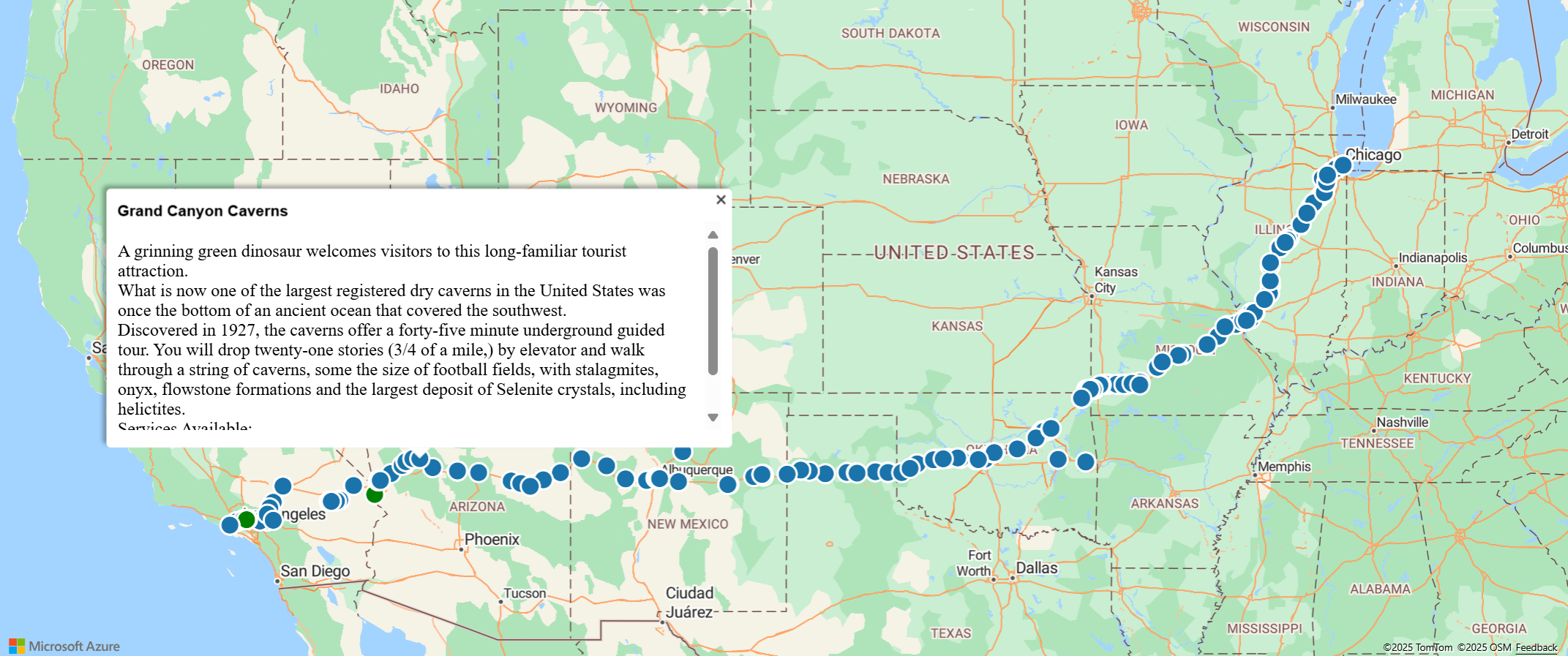

相關內容
本文僅說明空間 IO 模組中可用的許多功能之一。 若要瞭解其他人,請閱讀下列指南: