geo_point_to_geohash()
Calculates the geohash string value of a geographic location.
Read more about geohash.
Syntax
geo_point_to_geohash(longitude, latitude,[ accuracy ])
Learn more about syntax conventions.
Parameters
| Name | Type | Required | Description |
|---|---|---|---|
| longitude | real |
✔️ | Geospatial coordinate, longitude value in degrees. Valid value is a real number and in the range [-180, +180]. |
| latitude | real |
✔️ | Geospatial coordinate, latitude value in degrees. Valid value is a real number and in the range [-90, +90]. |
| accuracy | int |
Defines the requested accuracy. Supported values are in the range [1, 18]. If unspecified, the default value 5 is used. |
Returns
The geohash string value of a given geographic location with requested accuracy length. If the coordinate or accuracy is invalid, the query produces an empty result.
Note
- Geohash can be a useful geospatial clustering tool.
- Geohash has 18 accuracy levels with area coverage ranging from 25 Million km² at the highest level 1 to 0.6 μ² at the lowest level 18.
- Common prefixes of geohash indicate proximity of points to each other. The longer a shared prefix is, the closer the two places are. Accuracy value translates to geohash length.
- Geohash is a rectangular area on a plane surface.
- Invoking the geo_geohash_to_central_point() function on a geohash string that was calculated on longitude x and latitude y won't necessarily return x and y.
- Due to the geohash definition, it's possible that two geographic locations are very close to each other but have different geohash codes.
Geohash rectangular area coverage per accuracy value:
| Accuracy | Width | Height |
|---|---|---|
| 1 | 5000 km | 5000 km |
| 2 | 1250 km | 625 km |
| 3 | 156.25 km | 156.25 km |
| 4 | 39.06 km | 19.53 km |
| 5 | 4.88 km | 4.88 km |
| 6 | 1.22 km | 0.61 km |
| 7 | 152.59 m | 152.59 m |
| 8 | 38.15 m | 19.07 m |
| 9 | 4.77 m | 4.77 m |
| 10 | 1.19 m | 0.59 m |
| 11 | 149.01 mm | 149.01 mm |
| 12 | 37.25 mm | 18.63 mm |
| 13 | 4.66 mm | 4.66 mm |
| 14 | 1.16 mm | 0.58 mm |
| 15 | 145.52 μ | 145.52 μ |
| 16 | 36.28 μ | 18.19 μ |
| 17 | 4.55 μ | 4.55 μ |
| 18 | 1.14 μ | 0.57 μ |
See also geo_point_to_s2cell(), geo_point_to_h3cell().
For comparison with other available grid systems, see geospatial clustering with Kusto Query Language.
Examples
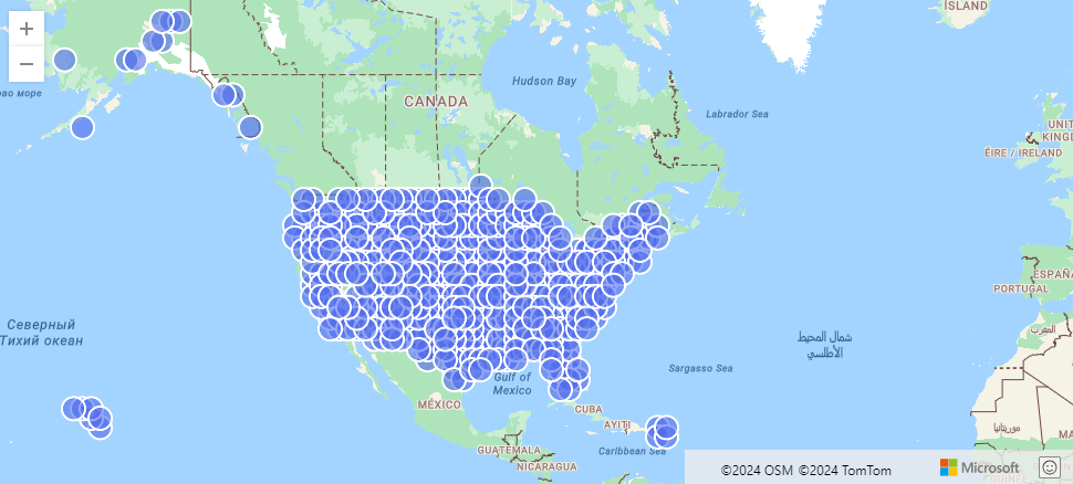
The following example finds US storm events aggregated by geohash.
StormEvents
| project BeginLon, BeginLat
| summarize by hash=geo_point_to_geohash(BeginLon, BeginLat, 3)
| project geo_geohash_to_central_point(hash)
| render scatterchart with (kind=map)
Output
The following example calculates and returns the geohash string value.
print geohash = geo_point_to_geohash(-80.195829, 25.802215, 8)
Output
| geohash |
|---|
| dhwfz15h |
The following example finds groups of coordinates. Every pair of coordinates in the group resides in a rectangular area of 4.88 km by 4.88 km.
datatable(location_id:string, longitude:real, latitude:real)
[
  "A", double(-122.303404), 47.570482,
  "B", double(-122.304745), 47.567052,
  "C", double(-122.278156), 47.566936,
]
| summarize count = count(),                                          // items per group count
            locations = make_list(location_id)                        // items in the group
            by geohash = geo_point_to_geohash(longitude, latitude)    // geohash of the group
Output
| geohash | count | locations |
|---|---|---|
| c23n8 | 2 | ["A", "B"] |
| c23n9 | 1 | ["C"] |
The following example produces an empty result because of the invalid coordinate input.
print geohash = geo_point_to_geohash(200,1,8)
Output
| geohash |
|---|
The following example produces an empty result because of the invalid accuracy input.
print geohash = geo_point_to_geohash(1,1,int(null))
Output
| geohash |
|---|
Feedback
Coming soon: Throughout 2024 we will be phasing out GitHub Issues as the feedback mechanism for content and replacing it with a new feedback system. For more information see: https://aka.ms/ContentUserFeedback.
Submit and view feedback for