Note
Access to this page requires authorization. You can try signing in or changing directories.
Access to this page requires authorization. You can try changing directories.
Note
Bing Maps Get a Static Map API retirement
Bing Maps Get a Static Map API is deprecated and has been retired for all free (Basic) account customers. Enterprise account customers can continue to use Bing Maps Get a Static Map API until June 30th, 2028. To avoid service disruptions, all enterprise account customers using Bing Maps Get a Static Map API will need to be updated to use Azure Maps Get Map Static Image API by June 30th, 2028.
Azure Maps is Microsoft's next-generation maps and geospatial services for developers. Azure Maps has many of the same features as Bing Maps for Enterprise, and more. To get started with Azure Maps, create a free Azure subscription and an Azure Maps account. For more information about azure Maps, see Azure Maps Documentation. For migration guidance, see Bing Maps Migration Overview.
When you use the Get a Static Map API to request static map image metadata, the response returns a Static Map Metadata resource that contains metadata about the static map including the absolute (latitude and longitude) and relative (with respect to the map) coordinates and size of pushpins, as well as the map area, size and center point. When you request static map metadata, the response does not return the map image. This topic contains descriptions of the static map metadata, followed by JSON and XML examples.
For more information about the common response syntax for the Bing Maps REST Services, see Common Response Description.
Static Map Metadata
The following fields are returned when you request image metadata for a static map.
| JSON | XML | Type | Description |
|---|---|---|---|
bbox |
BoundingBox |
BoundingBox. For more information about the BoundingBox type, see Location and Area Types. |
A geographic area that contains the location. A bounding box contains SouthLatitude, WestLongitude, NorthLatitude, and EastLongitude values in units of degrees. |
imageWidth |
ImageWidth |
integer |
The width of static map. |
imageHeight |
ImageHeight |
integer |
The height of the static map. |
mapCenter |
MapCenter |
Point. For more information about the Point type, see Location and Area Types. |
The centerpoint of the static map. |
zoom |
Zoom |
integer |
The zoom level of the static map. |
pushpinMetadata |
PushpinMetadata |
collection |
A collection of metadata for each pushpin on the static map. See the Pushpin Metadata section below for more information. |
Pushpin Metadata
If a static map contains pushpins, a request for static map metadata returns following information for each pushpin.
| JSON | XML | Type | Description |
|---|---|---|---|
point |
Point |
Point. For more information about the Point type, see Location and Area Types. |
The latitude and longitude coordinates of the pushpin. |
anchor |
Anchor |
An x (horizontal) and y (vertical) offset in pixels. |
The placement of the pushpin on the static map that is defined by an offset in pixels from the upper left hand corner of the map. |
topLeftOffset |
TopLeftOffset |
An x (horizontal) and y (vertical) offset in pixels. |
The offset of the top left corner of the pushpin icon with respect to the anchor point. |
bottomRightOffset |
BottomRightOffset |
An x (horizontal) and y (vertical) offset in pixels. |
The offset of the bottom right corner of the pushpin icon with respect to the anchor point. |
Examples
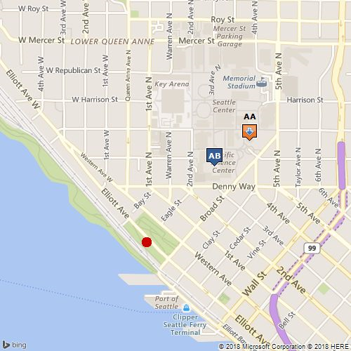
The following examples show the metadata that is returned for a static map. The static map is also shown for reference. When you request metadata for a static map, the map image is not returned.
Static Map Metadata Resource Example
The following URL gets static map metadata for the map image. The map image is not returned with static map metadata. XML and JSON static metadata responses are shown below.
http://dev.virtualearth.net/REST/v1/Imagery/Map/Road/47.619048,-122.35384/15?mapSize=500,500&pp=47.620495,-122.34931;21;AA&pp=47.619385,-122.351485;;AB&pp=47.616295,-122.3556;22&mapMetadata=1&o=xml&key={BingMapsKey}
This example returns the following response.
XML Response
<Response xmlns:xsi="http://www.w3.org/2001/XMLSchema-instance" xmlns:xsd="http://www.w3.org/2001/XMLSchema" xmlns="http://schemas.microsoft.com/search/local/ws/rest/v1">
  <Copyright>
    Copyright © 2011 Microsoft and its suppliers. All rights reserved. This API cannot be accessed and the content and any results may not be used, reproduced or transmitted in any manner without express written permission from Microsoft Corporation.
  </Copyright>
  <BrandLogoUri>
    http://dev.virtualearth.net/Branding/logo_powered_by.png
  </BrandLogoUri>
  <StatusCode>200</StatusCode>
  <StatusDescription>OK</StatusDescription>
  <AuthenticationResultCode>ValidCredentials</AuthenticationResultCode>
  <TraceId>
    d7718f0fa2344b23ad73ac2dd8788eec
  </TraceId>
  <ResourceSets>
    <ResourceSet>
      <EstimatedTotal>1</EstimatedTotal>
      <Resources>
        <StaticMapMetadata>
          <BoundingBox>
            <SouthLatitude>47.611833900404896</SouthLatitude>
            <WestLongitude>-122.36456394195557</WestLongitude>
            <NorthLatitude>47.626268662877358</NorthLatitude>
            <EastLongitude>-122.34314918518068</EastLongitude>
          </BoundingBox>
          <MapCenter>
            <Latitude>47.619048</Latitude>
            <Longitude>-122.35384</Longitude>
          </MapCenter>
          <ImageWidth>500</ImageWidth>
          <ImageHeight>500</ImageHeight>
          <Zoom>15</Zoom>
          <Pushpins>
            <PushpinMetadata>
              <Point>
                <Latitude>47.620495</Latitude>
                <Longitude>-122.34931</Longitude>
              </Point>
              <Anchor>
                <X>355</X>
                <Y>200</Y>
              </Anchor>
              <TopLeftOffset>
                <X>12</X>
                <Y>25</Y>
              </TopLeftOffset>
              <BottomRightOffset>
                <X>13</X>
                <Y>2</Y>
              </BottomRightOffset>
            </PushpinMetadata>
            <PushpinMetadata>
              <Point>
                <Latitude>47.619385</Latitude>
                <Longitude>-122.351485</Longitude>
              </Point>
              <Anchor>
                <X>305</X>
                <Y>238</Y>
              </Anchor>
              <TopLeftOffset>
                <X>12</X>
                <Y>28</Y>
              </TopLeftOffset>
              <BottomRightOffset>
                <X>13</X>
                <Y>0</Y>
              </BottomRightOffset>
            </PushpinMetadata>
            <PushpinMetadata>
              <Point>
                <Latitude>47.616295</Latitude>
                <Longitude>-122.3556</Longitude>
              </Point>
              <Anchor>
                <X>209</X>
                <Y>345</Y>
              </Anchor>
              <TopLeftOffset>
                <X>8</X>
                <Y>8</Y>
              </TopLeftOffset>
              <BottomRightOffset>
                <X>8</X>
                <Y>8</Y>
              </BottomRightOffset>
            </PushpinMetadata>
          </Pushpins>
        </StaticMapMetadata>
      </Resources>
    </ResourceSet>
  </ResourceSets>
</Response>
JSON Response
The following response is returned if the output parameter (o=xml) is not specified in the URL or is set to json (o=json).
{
   "authenticationResultCode":"ValidCredentials",
   "brandLogoUri":"http:\/\/dev.virtualearth.net\/Branding\/logo_powered_by.png",
   "copyright":"Copyright © 2011 Microsoft and its suppliers. All rights reserved. This API cannot be accessed and the content and any results may not be used, reproduced or transmitted in any manner without express written permission from Microsoft Corporation.",
   "resourceSets":[
      {
         "estimatedTotal":1,
         "resources":[
            {
               "__type":"StaticMapMetadata:http:\/\/schemas.microsoft.com\/search\/local\/ws\/rest\/v1",
               "bbox":[
                  47.611833900404896,
                  -122.36456394195557,
                  47.626268662877358,
                  -122.34314918518068
               ],
               "imageHeight":"500",
               "imageWidth":"500",
               "mapCenter":{
                  "type":"Point",
                  "coordinates":[
                     "47.619048",
                     "-122.35384"
                  ]
               },
               "pushpins":[
                  {
                     "anchor":{
                        "x":"355",
                        "y":"200"
                     },
                     "bottomRightOffset":{
                        "x":"13",
                        "y":"2"
                     },
                     "point":{
                        "type":"Point",
                        "coordinates":[
                           "47.620495",
                           "-122.34931"
                        ]
                     },
                     "topLeftOffset":{
                        "x":"12",
                        "y":"25"
                     }
                  },
                  {
                     "anchor":{
                        "x":"305",
                        "y":"238"
                     },
                     "bottomRightOffset":{
                        "x":"13",
                        "y":"0"
                     },
                     "point":{
                        "type":"Point",
                        "coordinates":[
                           "47.619385",
                           "-122.351485"
                        ]
                     },
                     "topLeftOffset":{
                        "x":"12",
                        "y":"28"
                     }
                  },
                  {
                     "anchor":{
                        "x":"209",
                        "y":"345"
                     },
                     "bottomRightOffset":{
                        "x":"8",
                        "y":"8"
                     },
                     "point":{
                        "type":"Point",
                        "coordinates":[
                           "47.616295",
                           "-122.3556"
                        ]
                     },
                     "topLeftOffset":{
                        "x":"8",
                        "y":"8"
                     }
                  }
               ],
               "zoom":"15"
            }
         ]
      }
   ],
   "statusCode":200,
   "statusDescription":"OK",
   "traceId":"bfc64b786a054288a4b160743ddfec65"
}