將多邊形立體化圖層新增至 iOS SDK 中的地圖 (預覽)
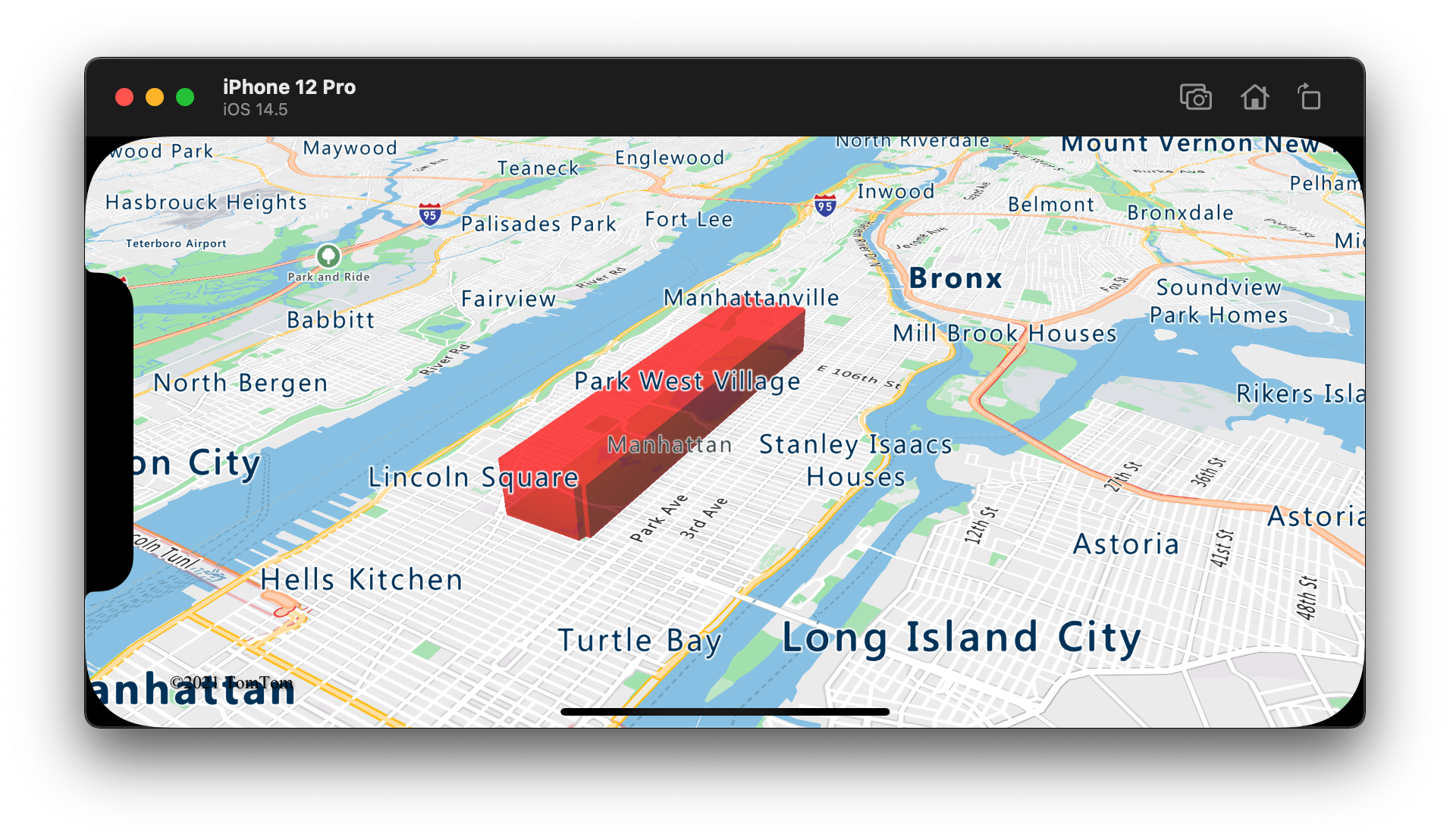
本文說明如何使用多邊形立體化圖層,轉譯幾何圖形 Polygon 和 MultiPolygon 的區域為立體圖形。
注意
Azure 地圖服務 iOS SDK 淘汰
適用於 iOS 的 Azure 地圖服務 原生 SDK 現在已被取代,將於 3/31/25 淘汰。 若要避免服務中斷,請依 3/31/25 移轉至 Azure 地圖服務 Web SDK。 如需詳細資訊,請參閱 Azure 地圖服務 iOS SDK 移轉指南。
使用多邊形立體化圖層
將多邊形立體化圖層連線至資料來源。 然後,在地圖上載入。 多邊形立體化圖層會轉譯圖形 Polygon 和 MultiPolygon 的區域為立體圖形。 多邊形立體化圖層的 height 和 base 屬性會以公尺為單位,定義與立體圖形底和高的基面距。 下列程式碼示範如何建立多邊形、新增多邊形至資料來源,及使用多邊形立體化圖層類別轉譯。
// Create a data source and add it to the map.
let source = DataSource()
map.sources.add(source)

// Create a rectangular polygon.
source.add(geometry: Polygon([
    CLLocationCoordinate2D(latitude: 40.800279, longitude: -73.958383),
    CLLocationCoordinate2D(latitude: 40.768459, longitude: -73.981547),
    CLLocationCoordinate2D(latitude: 40.767761, longitude: -73.981246),
    CLLocationCoordinate2D(latitude: 40.764616, longitude: -73.973618),
    CLLocationCoordinate2D(latitude: 40.765128, longitude: -73.973060),
    CLLocationCoordinate2D(latitude: 40.764908, longitude: -73.972599),
    CLLocationCoordinate2D(latitude: 40.796584, longitude: -73.949446),
    CLLocationCoordinate2D(latitude: 40.797088, longitude: -73.949661),
    CLLocationCoordinate2D(latitude: 40.800523, longitude: -73.957815),
    CLLocationCoordinate2D(latitude: 40.800279, longitude: -73.958383)
]))

// Create and add a polygon extrusion layer to the map below the labels so that they are still readable.
map.layers.insertLayer(
    PolygonExtrusionLayer(source: source, options: [
        .fillColor(.red),
        .fillOpacity(0.7),
        .height(500)
    ]),
    below: "labels"
)
下列螢幕擷取畫面顯示上述程式碼,即使用多邊形立體化圖層轉譯垂直縮放的多邊形。

新增資料驅動多邊形
您可以使用多邊形立體化圖層轉譯分區著色圖。 將立體化圖層的 height 和 fillColor 屬性設為幾何圖形 Polygon 和 MultiPolygon 的統計變數量測。 下列程式碼範例示範根據州別人口密度量測的美國立體分區著色圖。
// Create a data source and add it to the map.
let source = DataSource()

// Import the geojson data and add it to the data source.
source.importData(fromURL: Bundle.main.url(forResource: "US_States_Population_Density", withExtension: "json")!)

map.sources.add(source)

// Create and add a polygon extrusion layer to the map below the labels so that they are still readable.
let densityColorSteps: [Int: UIColor] = [
    0: UIColor(red: 0, green: 1, blue: 0.5, alpha: 1),
    10: UIColor(red: 9 / 255, green: 224 / 255, blue: 118 / 255, alpha: 1),
    20: UIColor(red: 11 / 255, green: 191 / 255, blue: 103 / 255, alpha: 1),
    50: UIColor(red: 247 / 255, green: 227 / 255, blue: 5 / 255, alpha: 1),
    100: UIColor(red: 247 / 255, green: 199 / 255, blue: 7 / 255, alpha: 1),
    200: UIColor(red: 247 / 255, green: 130 / 255, blue: 5 / 255, alpha: 1),
    500: UIColor(red: 247 / 255, green: 94 / 255, blue: 5 / 255, alpha: 1),
    1000: UIColor(red: 247 / 255, green: 37 / 255, blue: 5 / 255, alpha: 1)
]
let colorExpression = NSExpression(
    forAZMStepping: NSExpression(forKeyPath: "density"),
    from: NSExpression(forConstantValue: UIColor(red: 0, green: 1, blue: 0.5, alpha: 1)),
    stops: NSExpression(forConstantValue: densityColorSteps)
)

let densityHeightSteps: [Int: Int] = [
    0: 100,
    1200: 960_000
]
let heightExpression = NSExpression(
    forAZMInterpolating: NSExpression(forKeyPath: "density"),
    curveType: .linear,
    parameters: nil,
    stops: NSExpression(forConstantValue: densityHeightSteps)
)

map.layers.insertLayer(
    PolygonExtrusionLayer(source: source, options: [
        .fillOpacity(0.7),
        .fillColor(from: colorExpression),
        .height(from: heightExpression)
    ]),
    below: "labels"
)
下列螢幕擷取畫面顯示根據人口密度,以立體多邊形垂直縮放的美國各州分區著色圖。
其他資訊
請參閱下列文章,以取得更多可新增至地圖的程式碼範例:
