MapScene.CreateFromLocations 方法
定義
重要
部分資訊涉及發行前產品,在發行之前可能會有大幅修改。 Microsoft 對此處提供的資訊,不做任何明確或隱含的瑕疵擔保。
多載
| CreateFromLocations(IIterable<Geopoint>) |
建立場景,以根據多個地理位置出現在地圖中。 |
| CreateFromLocations(IIterable<Geopoint>, Double, Double) |
根據多個地理位置、標題和音調,建立要出現在地圖中的場景。 |
CreateFromLocations(IIterable<Geopoint>)
建立場景,以根據多個地理位置出現在地圖中。
public:
 static MapScene ^ CreateFromLocations(IIterable<Geopoint ^> ^ locations);
/// [Windows.Foundation.Metadata.Overload("CreateFromLocations")]
static MapScene CreateFromLocations(IIterable<Geopoint> const& locations);[Windows.Foundation.Metadata.Overload("CreateFromLocations")]
public static MapScene CreateFromLocations(IEnumerable<Geopoint> locations);function createFromLocations(locations)Public Shared Function CreateFromLocations (locations As IEnumerable(Of Geopoint)) As MapScene參數
- locations
要出現在場景中的位置。
傳回
代表 MapControl中地圖的檢視。
- 屬性
備註
此建構函式相當於呼叫 CreateFromLocations (IIterable (Geopoint) 、Double、Double) 與下列預設參數值: headingInDegrees = 0 (North) 和 pitchInDegrees = 0 (直接向下) 。 如需詳細資訊,請參閱 CreateFromLocations (IIterable (Geopoint) 、Double、Double) 方法。
另請參閱
適用於
CreateFromLocations(IIterable<Geopoint>, Double, Double)
根據多個地理位置、標題和音調,建立要出現在地圖中的場景。
public:
 static MapScene ^ CreateFromLocations(IIterable<Geopoint ^> ^ locations, double headingInDegrees, double pitchInDegrees);
/// [Windows.Foundation.Metadata.Overload("CreateFromLocationsWithHeadingAndPitch")]
static MapScene CreateFromLocations(IIterable<Geopoint> const& locations, double const& headingInDegrees, double const& pitchInDegrees);[Windows.Foundation.Metadata.Overload("CreateFromLocationsWithHeadingAndPitch")]
public static MapScene CreateFromLocations(IEnumerable<Geopoint> locations, double headingInDegrees, double pitchInDegrees);function createFromLocations(locations, headingInDegrees, pitchInDegrees)Public Shared Function CreateFromLocations (locations As IEnumerable(Of Geopoint), headingInDegrees As Double, pitchInDegrees As Double) As MapScene參數
- locations
要出現在場景中的位置。
- headingInDegrees
-
Double
double
地圖相機的方向標題,其中 0 或 360 = North、90 = East、180 = South 和 270 = West。 預設 標題InDegrees 值為 0。
- pitchInDegrees
-
Double
double
地圖相機的間距以度為單位,其中 90 個視線 (最大) ,0 會直接向下看 (最小) 。 預設 的 pitchInDegrees 值為 0。
傳回
代表 MapControl中地圖的檢視。
- 屬性
備註
提示
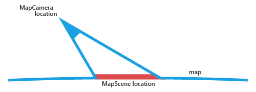
使用 CreateFromCamera 方法可藉由指定地圖相機的位置來建立場景。 locations參數指定于這個方法中的位置是場景中顯示的位置,不是地圖相機的位置。
下圖示范相對於地圖相機的場景位置。 由 locations參數指定于此方法中的位置會對應至MapScene 位置。
 2D、3D 和 Streetside 地圖檢視之間的有效間距範圍不同。 例如,從 3D 切換至 2D 時,目前檢視中可接受的值可能超出下一個檢視的範圍。 如果是這種情況,目前的間距值將會截斷為下一個檢視中最接近可接受的值。
離開 Streetside 檢視時,地圖會返回先前的檢視設定。 Streetside 間距不會在 Streetside 體驗之外維護。
間距/傾斜的最大值和最小值取決於地圖檢視的類型:2D、3D 或 Streetside。
| 屬性 | 2D 範圍 | 3D 範圍 | 街邊範圍 |
|---|---|---|---|
| 傾斜/傾斜 | 0-75 | 0-90 | 0-180 |
大於 360 度的標題值會正規化為相等的 0-360 度值。
另請參閱
適用於
意見反應
即將登場:在 2024 年,我們將逐步淘汰 GitHub 問題作為內容的意見反應機制,並將它取代為新的意見反應系統。 如需詳細資訊,請參閱:https://aka.ms/ContentUserFeedback。
提交並檢視相關的意見反應