Note
Access to this page requires authorization. You can try signing in or changing directories.
Access to this page requires authorization. You can try changing directories.
Note
Bing Maps Web Control SDK retirement
Bing Maps Web Control SDK is deprecated and has been retired for all free (Basic) account customers. Enterprise account customers can continue to use Bing Maps Web Control SDK until June 30th, 2028. To avoid service disruptions, all enterprise account customers using Bing Maps Web Control SDK will need to be updated to use Azure Maps Web SDK by June 30th, 2028. For detailed migration guidance, see Migrate from Bing Maps Web Control SDK and Migrate Bing Maps Enterprise applications to Azure Maps with GitHub Copilot.
Azure Maps is Microsoft's next-generation maps and geospatial services for developers. Azure Maps has many of the same features as Bing Maps for Enterprise, and more. To get started with Azure Maps, create a free Azure subscription and an Azure Maps account. For more information about azure Maps, see Azure Maps Documentation. For migration guidance, see Bing Maps Migration Overview.
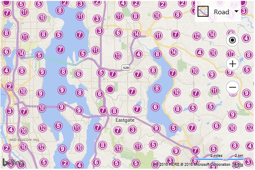
The following code example loads the Clustering module and then generates 1,000 random pushpins that are within the current map view using the TestDataGenerator class, which is built into the V8 map control. It then creates an instance of the ClusterLayer class and passes in the pushpins to be clustered and inserts it into the map.
<!DOCTYPE html>
<html>
<head>
    <title></title>
    <meta charset="utf-8" />
	<script type="text/javascript">
    var map, clusterLayer;

    function GetMap() {
        map = new Microsoft.Maps.Map('#myMap', {});

        //Load the Clustering module.
        Microsoft.Maps.loadModule("Microsoft.Maps.Clustering", function () {
            //Generate 1,000 random pushpins in the map view.
            var pins = Microsoft.Maps.TestDataGenerator.getPushpins(1000, map.getBounds());

            //Create a ClusterLayer and add it to the map.
            clusterLayer = new Microsoft.Maps.ClusterLayer(pins);
            map.layers.insert(clusterLayer);
        });
    }
    </script>
    <script type='text/javascript' src='http://www.bing.com/api/maps/mapcontrol?callback=GetMap&key=[YOUR_BING_MAPS_KEY]' async defer></script>
</head>
<body>
    <div id="myMap" style="position:relative;width:600px;height:400px;"></div>
</body>
</html>
Running this code in a browser will display a map with a bunch of pushpins on it. Those that have numbers on them are clusters of pushpins. As you zoom the map towards a cluster you will see the cluster break apart into its individual pushpins.