Topography Overlay
Note
Bing Maps Web Control SDK retirement
Bing Maps Web Control SDK is deprecated and will be retired. Free (Basic) account customers can continue to use Bing Maps Web Control SDK until June 30th, 2025. Enterprise account customers can continue to use Bing Maps Web Control SDK until June 30th, 2028. To avoid service disruptions, all implementations using Bing Maps Web Control SDK will need to be updated to use Azure Maps Web SDK by the retirement date that applies to your Bing Maps for Enterprise account type. For detailed migration guidance, see Migrate from Bing Maps Web Control SDK and Migrate Bing Maps Enterprise applications to Azure Maps with GitHub Copilot.
Azure Maps is Microsoft's next-generation maps and geospatial services for developers. Azure Maps has many of the same features as Bing Maps for Enterprise, and more. To get started with Azure Maps, create a free Azure subscription and an Azure Maps account. For more information about azure Maps, see Azure Maps Documentation. For migration guidance, see Bing Maps Migration Overview.
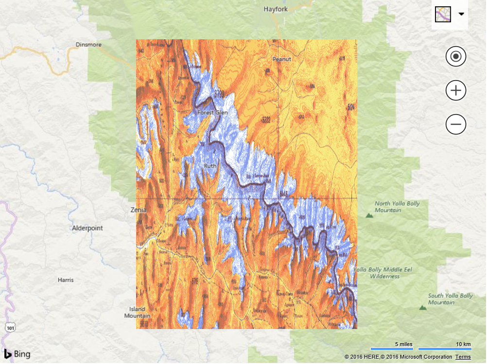
This example creates a custom overlay that stretches an image such that the corners are bound to a bounding box on the map. This is useful when you want to overlay a geo-referenced image on that map without having to turn it into a tile layer. Some common scenarios where this might be used is when overlaying images of floor plans, campus maps, or individual satellite images on the map.
<!DOCTYPE html>
<html>
<head>
    <title></title>
    <meta charset="utf-8" />
	<script type='text/javascript'>
    var map;

    function GetMap()
    {
        map = new Microsoft.Maps.Map('#myMap', {
            credentials: 'Your Bing Maps Key',
            center: new Microsoft.Maps.Location(40.25, -123.25),
            zoom: 8
        });

        //Define a custom overlay class that inherts from the CustomOverlay class.
        TopographicOverlay.prototype = new Microsoft.Maps.CustomOverlay();

        //Define a constructor for the custom overlay class.
        function TopographicOverlay(bounds, image) {
            this.bounds = bounds;
            this.image = image;
        }

        //Implement the onAdd method to set up DOM elements, and use setHtmlElement to bind it with the overlay.
        TopographicOverlay.prototype.onAdd = function () {
            //Create an image element that will be used as the overlay.
            img = document.createElement('img');
            img.src = this.image;
            img.style.width = '100%';
            img.style.height = '100%';
            img.style.position = 'absolute';
            this.setHtmlElement(img);
        };

        //Implement the onLoad method to perform custom operations of rendering the DOM element.
        TopographicOverlay.prototype.onLoad = function () {
            repositionOverlay();

            //Update the position of the image when the view changes.
            Microsoft.Maps.Events.addHandler(map, 'viewchange', function () {
                repositionOverlay();
            });
        };

        function repositionOverlay() {
            //Streach and position the image based on the bounding box pixel coordinates.
            var topLeft = map.tryLocationToPixel(bounds.getNorthwest(), Microsoft.Maps.PixelReference.control);
            var bottomRight = map.tryLocationToPixel(bounds.getSoutheast(), Microsoft.Maps.PixelReference.control);

            img.style.left = topLeft.x + 'px';
            img.style.top = topLeft.y + 'px';
            img.style.width = (bottomRight.x - topLeft.x) + 'px';
            img.style.width = (bottomRight.x - topLeft.x) + 'px';
            img.style.height = (bottomRight.y - topLeft.y) + 'px';
        }

        //The bounding box and url for the image to overlay.
        var bounds = Microsoft.Maps.LocationRect.fromCorners(new Microsoft.Maps.Location(40.5, -123.5), new Microsoft.Maps.Location(40, -123));
        var imageSrc = 'https://bingmapsisdk.blob.core.windows.net/isdksamples/topographicMap.gif';

        //Implement the new custom overlay class.
        var overlay = new TopographicOverlay(bounds, imageSrc);

        //Add the custom overlay to the map.
        map.layers.insert(overlay);
    }
    </script>
    <script type='text/javascript' src='http://www.bing.com/api/maps/mapcontrol?callback=GetMap' async defer></script>
</head>
<body>
    <div id="myMap" style="position:relative;width:800px;height:600px;"></div>
</body>
</html>
Running this code will overlay a topographic image of a mountain range on top of the map. As you pan and zoom you will notice that the corners of the image stay bounded to the specified bounding box and stretches as needed based on zoom level.