Note
Access to this page requires authorization. You can try signing in or changing directories.
Access to this page requires authorization. You can try changing directories.
Note
Bing Maps Web Control SDK retirement
Bing Maps Web Control SDK is deprecated and has been retired for all free (Basic) account customers. Enterprise account customers can continue to use Bing Maps Web Control SDK until June 30th, 2028. To avoid service disruptions, all enterprise account customers using Bing Maps Web Control SDK will need to be updated to use Azure Maps Web SDK by June 30th, 2028. For detailed migration guidance, see Migrate from Bing Maps Web Control SDK and Migrate Bing Maps Enterprise applications to Azure Maps with GitHub Copilot.
Azure Maps is Microsoft's next-generation maps and geospatial services for developers. Azure Maps has many of the same features as Bing Maps for Enterprise, and more. To get started with Azure Maps, create a free Azure subscription and an Azure Maps account. For more information about azure Maps, see Azure Maps Documentation. For migration guidance, see Bing Maps Migration Overview.
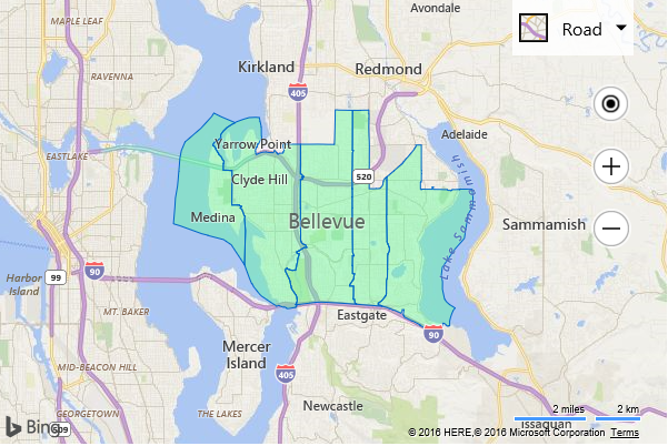
Displaying the boundary of a single location is useful, but sometimes you need to display the boundaries of several locations at once. This code sample shows how to request the boundaries for 5 zip codes and render them on the map.
<!DOCTYPE html>
<html>
<head>
    <title></title>
    <meta charset="utf-8" />
	<script type='text/javascript'>
    function GetMap() {
        var map = new Microsoft.Maps.Map('#myMap', {
            credentials: ‘Your Bing Maps Key’,
            center: new Microsoft.Maps.Location(47.614, -122.165),
            zoom: 11
        });

        //Create an array of locations to get the boundaries of.
        var zipCodes = ['98004', '98005', '98007', '98008', '98039'];

        //Create the request options.
        var geoDataRequestOptions = {
            entityType: 'Postcode1'
        };

        //Load the Bing Spatial Data Services module.
        Microsoft.Maps.loadModule('Microsoft.Maps.SpatialDataService', function () {

            //Use the GeoData API manager to get the boundaries of the zip codes.
            Microsoft.Maps.SpatialDataService.GeoDataAPIManager.getBoundary(
                zipCodes,
                geoDataRequestOptions,
                map,
                function (data) {
                    //This callback function will be called once for each zip code.
                    //Add the polygons to the map.
                    if (data.results && data.results.length > 0) {
                        map.entities.push(data.results[0].Polygons);
                    }
                });
        });
    }
    </script>
    <script type='text/javascript' src='http://www.bing.com/api/maps/mapcontrol?callback=GetMap' async defer></script>
</head>
<body>
    <div id="myMap" style="position:relative;width:600px;height:400px;"></div>
</body>
</html>
Running this code will load a map that displays the boundaries of 5 zip codes that are in the city of Bellevue, WA.