using System;
using Windows.UI.Xaml;
using Windows.UI.Xaml.Controls;
using Windows.Services.Maps;
using Windows.Devices.Geolocation;
...
privateasyncvoidbutton_Click(object sender, RoutedEventArgs e)
{
// Start at Microsoft in Redmond, Washington.
BasicGeoposition startLocation = new BasicGeoposition() {Latitude=47.643,Longitude=-122.131};
// End at the city of Seattle, Washington.
BasicGeoposition endLocation = new BasicGeoposition() {Latitude = 47.604,Longitude= -122.329};
// Get the route between the points.
MapRouteFinderResult routeResult =
await MapRouteFinder.GetDrivingRouteAsync(
new Geopoint(startLocation),
new Geopoint(endLocation),
MapRouteOptimization.Time,
MapRouteRestrictions.None);
if (routeResult.Status == MapRouteFinderStatus.Success)
{
System.Text.StringBuilder routeInfo = new System.Text.StringBuilder();
// Display summary info about the route.
routeInfo.Append("Total estimated time (minutes) = ");
routeInfo.Append(routeResult.Route.EstimatedDuration.TotalMinutes.ToString());
routeInfo.Append("\nTotal length (kilometers) = ");
routeInfo.Append((routeResult.Route.LengthInMeters / 1000).ToString());
// Display the directions.
routeInfo.Append("\n\nDIRECTIONS\n");
foreach (MapRouteLeg leg in routeResult.Route.Legs)
{
foreach (MapRouteManeuver maneuver in leg.Maneuvers)
{
routeInfo.AppendLine(maneuver.InstructionText);
}
}
// Load the text box.
tbOutputText.Text = routeInfo.ToString();
}
else
{
tbOutputText.Text =
"A problem occurred: " + routeResult.Status.ToString();
}
}
この例では、tbOutputText テキスト ボックスに次の結果が表示されます。
出力
Total estimated time (minutes) = 18.4833333333333
Total length (kilometers) = 21.847

DIRECTIONS
Head north on 157th Ave NE.
Turn left onto 159th Ave NE.
Turn left onto NE 40th St.
Turn left onto WA-520 W.
Enter the freeway WA-520 from the right.
Keep left onto I-5 S/Portland.
Keep right and leave the freeway at exit 165A towards James St..
Turn right onto James St.
You have reached your destination.
using System;
using Windows.Devices.Geolocation;
using Windows.Services.Maps;
using Windows.UI;
using Windows.UI.Xaml.Controls;
using Windows.UI.Xaml.Controls.Maps;
...
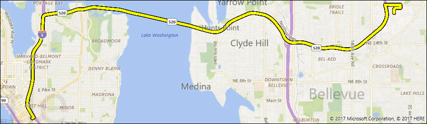
privateasyncvoidShowRouteOnMap()
{
// Start at Microsoft in Redmond, Washington.
BasicGeoposition startLocation = new BasicGeoposition() { Latitude = 47.643, Longitude = -122.131 };
// End at the city of Seattle, Washington.
BasicGeoposition endLocation = new BasicGeoposition() { Latitude = 47.604, Longitude = -122.329 };
// Get the route between the points.
MapRouteFinderResult routeResult =
await MapRouteFinder.GetDrivingRouteAsync(
new Geopoint(startLocation),
new Geopoint(endLocation),
MapRouteOptimization.Time,
MapRouteRestrictions.None);
if (routeResult.Status == MapRouteFinderStatus.Success)
{
// Use the route to initialize a MapRouteView.
MapRouteView viewOfRoute = new MapRouteView(routeResult.Route);
viewOfRoute.RouteColor = Colors.Yellow;
viewOfRoute.OutlineColor = Colors.Black;
// Add the new MapRouteView to the Routes collection// of the MapControl.
MapWithRoute.Routes.Add(viewOfRoute);
// Fit the MapControl to the route.await MapWithRoute.TrySetViewBoundsAsync(
routeResult.Route.BoundingBox,
null,
Windows.UI.Xaml.Controls.Maps.MapAnimationKind.None);
}
}