了解如何使用客户端呈现以编程方式自定义 SharePoint 地理位置字段类型。
SharePoint 引入了一个名为 地理位置 的新字段类型,使您能够用位置信息注释 SharePoint 列表。 在类型地理位置列中,可输入十进制度数的纬度和经度坐标对形式的位置信息,或从浏览器检索用户的当前位置的坐标 (如果其实现 W3C 地理位置 API)。 有关“地理位置”字段的详细信息,请参阅 在 SharePoint 中集成位置和地图功能。
在 SharePoint 中的任何列表或文档库的默认内容类型中,地理位置字段类型不可用。 SharePoint 中包括地理位置字段类型,但在列表的创建列页面上不可见;必须以编程方式添加地理位置字段类型。 有关详细信息,请参阅 如何:在 SharePoint 中以编程方式向列表添加地理位置列。
向 SharePoint 中添加地理位置字段类型后,可通过 Bing 地图利用它呈现地图。 内置的地理位置字段仅可通过 Bing 地图呈现。 但是,可通过将地理位置字段用作父字段类型来创建自定义字段。 自定义呈现可通过客户端呈现框架中的 JSLink 属性提供。 客户端呈现框架是在 SharePoint 中引入的。 有关详细信息,请参阅 如何:使用客户端呈现自定义字段类型。
注意
JSLink 属性在“调查”或“事件”列表上不受支持。 SharePoint 日历是事件列表。
本部分中的过程介绍了如何使用客户端呈现功能,创建派生自“地理位置”字段类型的自定义字段。
创建自定义地理位置字段的先决条件
必须具备以下内容:
- 一台运行 SharePoint 的服务器。
- Microsoft Visual Studio 2012
- Visual Studio 2012 Office 开发人员工具
- 对 SharePoint 列表的访问权限,并具有可添加列的足够的权限。
自定义地理位置字段要知道的核心概念
表 1. 扩展地理位置字段类型的核心概念
| 文章标题 | 描述 |
|---|---|
|
集成 SharePoint 中的位置和映射功能 |
了解如何通过使用新地理位置字段和创建您自己的基于地理位置的字段类型,集成 SharePoint 列表和基于位置的 Web 和移动应用程序中的位置信息和地图。 |
|
如何:使用客户端呈现自定义字段类型 |
了解有关 SharePoint 中引入的新客户端呈现的详细内容。 |
|
如何:在 SharePoint 中以编程方式向列表添加 Geolocation 列 |
了解如何在 SharePoint 中以编程方式向列表添加地理位置列。 |
步骤 1:设置 Visual Studio 项目
设置自定义字段项目的具体步骤
在安装 SharePoint 的计算机上,启动 Visual Studio 2012。
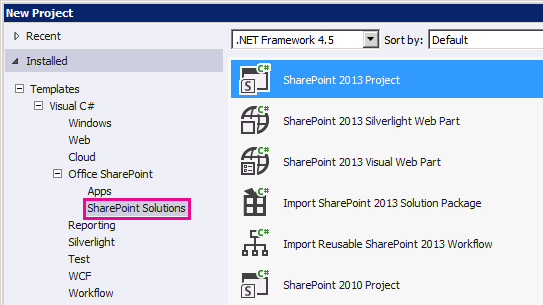
在“新建项目”对话框的“已安装”模板下,依次选择“Visual C#”、“Office SharePoint”和“SharePoint 解决方案”。 选择“SharePoint”项目类型。 图 1 展示了“SharePoint 项目”模板在 Visual Studio 2012 中的位置。 将它设为场解决方案,而不是沙盒解决方案。
图 1. Visual Studio 中的 SharePoint 项目模板
为该项目指定名称。 我们在此示例中使用"CustomGeolocationField"。 然后选择"确定"按钮。
在"SharePoint 自定义向导"中,输入要将新自定义字段类型部署到的 SharePoint 网站的 URL。
在"解决方案资源管理器"中,打开项目名称(在我们的示例中,为"CustomGeolocationField")的快捷菜单,然后选择"添加"、"新建项"。
在"添加新项"对话框中的"代码"模板下,选择"类",并指定类的名称(在此示例中为"CustomGeolocationField.cs")。
在"解决方案资源管理器"中,打开项目名称的快捷菜单,然后选择"添加"、"SharePoint 映射文件夹"。
在“添加 SharePoint 映射文件夹”对话框中,使用树控件将该文件夹映射到“模板/布局”,并选择“确定”按钮。
在“解决方案资源管理器”中,打开新的 LAYOUTS 文件夹(而不是项目名称)的快捷菜单,然后选择“添加”、“新建项”。
在"添加新项"对话框中,选择"Visual C#"、"Web" ,然后选择"模板"下的"Javascript 文件"。
在“名称”框中,指定文件名(在此示例中,为“CustomGeolocationField”),再选择“添加”。
重复步骤 8 以创建另一个 SharePoint 映射文件夹,并将其映射到 TEMPLATE\XML。 然后选择“确定”按钮。
在“解决方案资源管理器”中,打开新“XML”文件夹的快捷菜单(而非项目名称),再依次选择“添加”和“新项”。
在"添加新项"对话框中,选择"Visual C#"、"数据" ,然后选择"模板"下的"XML 文件"。
在“ 名称 ”框中,指定此示例 ( 文件的名称usesfldtypes_CustomGeolocationControl.xml) ,然后选择“ 添加 ”按钮。
步骤 2:创建自定义字段类
字段类是一种类,其实例可以表示基于您的自定义字段类型的特殊字段。 此类必须继承自 SPField 或者 SharePoint Foundation 中从其派生的一个类。 若要使您能够扩展或自定义地理位置字段类型,此类必须继承自 SPFieldGeolocation。 有关创建字段类型的详细信息,请参阅演练:创建自定义字段类型。
注意
在此示例中,类和解决方案名为“CustomGeolocationField”;可以在创建 Visual Studio 项目时,根据需要指定类和项目的名称。
创建自定义字段类的具体步骤
打开 CustomGeolocationField.cs 文件,并添加指令
using,如下所示。using System; using Microsoft.SharePoint; using Microsoft.SharePoint.WebControls;确保命名空间为
CustomGeolocationField。请确保类命名
CustomGeolocationField为 ,并更改其声明以指定它继承自SPFieldGeolocation。 为该类添加以下所需构造函数。public class CustomGeolocationField : SPFieldGeolocation { /// <summary> /// Create an instance of CustomGeolocationField object. /// </summary> /// <param name="fields">Field collection</param> /// <param name="fieldName">Name of the field</param> /// public CustomGeolocationField(SPFieldCollection fields, string fieldName) : base(fields, fieldName) { } /// <summary> /// Create an instance of CustomGeolocationField object. /// </summary> /// <param name="fields">Field collection</param> /// <param name="typeName">type name of the field</param> /// <param name="displayName">display name of the field</param> public CustomGeolocationField(SPFieldCollection fields, string typeName, string displayName) : base(fields, typeName, displayName) { }将 方法的
JSLink以下重写添加到 类。 CustomGeolocationControl.js 是在后面的步骤中创建的 JavaScript 文件。 通过提供您自己的 JavaScript 文件,重写 Bing 地图的默认呈现。 如果您未重写此方法,则默认呈现将来自 Bing 地图。 属性JSLink在 SharePoint 中引入。 有关 属性的详细信息JSLink,请参阅 如何:使用客户端呈现自定义字段类型。/// <summary> /// Override JSLink property. /// </summary> public override string JSLink { get { return "CustomGeolocationControl.js"; } set { base.JSLink = value; } }方法
GetFieldValue()将指定的值转换为字段类型值。 有关 方法的详细信息GetFieldValue(),请参阅 GetFieldValue (String) 。 将 方法的GetFieldValue()以下重写添加到CustomGeolocationField类。/// <summary> /// get the field values /// </summary> /// <param name="value"></param> /// <returns></returns> public override object GetFieldValue(string value) { return base.GetFieldValue(value); }将 GetValidatedString 方法的以下重写添加到
CustomGeolocationField类:/// <summary> /// get validated string /// </summary> /// <param name="value"></param> /// <returns></returns> public override string GetValidatedString(object value) { return base.GetValidatedString(value); }
步骤 3:创建新自定义字段的呈现
接下来,应创建字段类的 方法指向的 JavaScript 文件 JSLink 。 此文件应使用新客户端呈现框架定义自定义字段类型的呈现。 有关详细信息,请参阅 如何:使用客户端呈现自定义字段类型。
以下示例显示注册 SharePoint 中引入的客户端呈现框架的注册逻辑。
function _registerCustomGeolocationFieldTemplate() {
    var geolocationFieldContext = {};
    geolocationFieldContext.Templates = {};
    geolocationFieldContext.Templates.Fields = {

        'CustomGeolocationField': {
            'View': CustomGeolocationFieldTemplate.RenderGeolocationField,
            'DisplayForm': CustomGeolocationFieldTemplate.SPFieldGeolocation_Display,
            'EditForm': CustomGeolocationFieldTemplate.SPFieldGeolocation_Edit,
            'NewForm': CustomGeolocationFieldTemplate.SPFieldGeolocation_Edit
        }
    };
    SPClientTemplates.TemplateManager.RegisterTemplateOverrides(geolocationFieldContext);
}
在注册过程中,共涉及四个变量及其各自的方法。 客户端呈现框架调用这些方法来呈现 CustomGeolocationControl。
以下代码示例为派生自"地理位置"的新自定义字段创建新呈现。
创建 JavaScript 文件
创建文本文件并指定名称(如 x),为其指定.js扩展名,并将其保存到 SharePoint 映射的 TEMPLATE\LAYOUTS 文件夹。 此示例使用名称 CustomGeolocationControl.js。
将以下代码复制到 .js 文件中。
(function () { if (typeof CustomGeolocationFieldTemplate == "object") { return; } window.CustomGeolocationFieldTemplate = (function () { return { SPFieldGeolocation_Display: function (rCtx) { if (rCtx == null || rCtx.CurrentFieldValue == null || rCtx.CurrentFieldValue == '') return ''; var listItem = rCtx['CurrentItem']; var fldvalue = CustomGeolocationFieldTemplate.ParseGeolocationValue(listItem[rCtx.CurrentFieldSchema.Name]); var _myData = SPClientTemplates.Utility.GetFormContextForCurrentField(rCtx); if (_myData == null || _myData.fieldSchema == null) return ''; var _latitude = 0; var _longitude = 0; if (fldvalue != null) { _latitude = fldvalue.latitude; _longitude = fldvalue.longitude; } var result = '<div>'; result += '<span>Latitude:</span><span>' + _latitude + '</span><span>Longitude:</span><span>' + _longitude + '</span>'; result += '</div>'; return result; }, ParseGeolocationValue: function (fieldValue) { if (fieldValue == null || fieldValue == '') return null; var point = new Object(); point.longitude = null; point.latitude = null; point.altitude = null; point.measure = null; var matches = fieldValue.match(/POINT\\s*\\((\\d+(\\.\\d+)?)\\s+(\\d+(\\.\\d+)?)\\s+(\\d+(\\.\\d+)?)\\s+(\\d+(\\.\\d+)?)\\)/i); if (matches != null) { point.longitude = parseFloat(matches[1]); point.latitude = parseFloat(matches[3]); point.altitude = parseFloat(matches[5]); point.measure = parseFloat(matches[7]); } else { matches = fieldValue.match(/POINT\\s*\\((\\d+(\\.\\d+)?)\\s+(\\d+(\\.\\d+)?)\\)/i); if (matches != null) { point.longitude = parseFloat(matches[1]); point.latitude = parseFloat(matches[3]); } } return point; }, SPFieldGeolocation_Edit: function (rCtx) { if (rCtx == null) return ''; var _myData = SPClientTemplates.Utility.GetFormContextForCurrentField(rCtx); if (_myData == null || _myData.fieldSchema == null) return ''; var _latitude = null; var _longitude = null; var _inputId_Latitude = _myData.fieldName + '_' + _myData.fieldSchema.Id + '_$geolocationField_Latitude'; var _inputId_Longitude = _myData.fieldName + '_' + _myData.fieldSchema.Id + '_$geolocationField_Longitude'; var _inputId_Div = _myData.fieldName + '_' + _myData.fieldSchema.Id + '_$geolocationField_Div'; var _latitudeBox = null; var _longitudeBox = null; var _value = _myData.fieldValue != null ? _myData.fieldValue : ''; var listItem = rCtx['CurrentItem']; var fldvalue = CustomGeolocationFieldTemplate.ParseGeolocationValue(listItem[rCtx.CurrentFieldSchema.Name]); if (fldvalue != null) { _latitude = fldvalue.latitude; _longitude = fldvalue.longitude; } var validators = new SPClientForms.ClientValidation.ValidatorSet(); if (_myData.fieldSchema.Required) validators.RegisterValidator(new SPClientForms.ClientValidation.RequiredValidator()); _myData.registerClientValidator(_myData.fieldName, validators); // Post DOM initialization callback. _myData.registerInitCallback(_myData.fieldName, function () { // Initialize the input control references. _latitudeBox = document.getElementById(_inputId_Latitude); _longitudeBox = document.getElementById(_inputId_Longitude); // Set the initial values. if ((_latitudeBox != null && _longitudeBox != null) && (_latitude != null && _longitude != null)) { _latitudeBox.value = _latitude; _longitudeBox.value = _longitude; } }); // On focus call back. _myData.registerFocusCallback(_myData.fieldName, function () { if (_latitudeBox != null) _latitudeBox.focus(); }); // Validation failure handler. _myData.registerValidationErrorCallback(_myData.fieldName, function (errorResult) { SPFormControl_AppendValidationErrorMessage(_inputId_Div, "invalid Geolocation Field"); }); // Register a callback just before submit. _myData.registerGetValueCallback(_myData.fieldName, function () { if (_latitudeBox == null && _longitudeBox == null) return ''; else { _latitude = _latitudeBox.value; _longitude = _longitudeBox.value; if (_latitude != null && _longitude != null) return "Point(" + _longitude + " " + _latitude + ")"; } }); _myData.updateControlValue(_myData.fieldName, _value); var result = '<div width="100%" id=' + STSHtmlEncode(_inputId_Div) + '>'; result += '<div><span>Latitude:</span><input id=' + STSHtmlEncode(_inputId_Latitude) + ' type="text" name="Latitude" /></div>'; result += '<div><span>Longitude:</span><input id=' + STSHtmlEncode(_inputId_Longitude) + ' type="text" name="Longitude" /></div>'; result += '</div>'; return result; }, RenderGeolocationField: function (inCtx, field, listItem, listSchema) { var fldvalue = CustomGeolocationFieldTemplate.ParseGeolocationValue(listItem[field.Name]); var result = ''; if (fldvalue != null) { var result = '<div>'; result += '<span>Latitude:</span><span>' + fldvalue.latitude + '</span><span>Longitude:</span><span>' + fldvalue.longitude + '</span>'; result += '</div>'; } return result; } }; })(); function _registerCustomGeolocationFieldTemplate() { var geolocationFieldContext = {}; geolocationFieldContext.Templates = {}; geolocationFieldContext.Templates.Fields = { 'CustomGeolocationField': { 'View': CustomGeolocationFieldTemplate.RenderGeolocationField, 'DisplayForm': CustomGeolocationFieldTemplate.SPFieldGeolocation_Display, 'EditForm': CustomGeolocationFieldTemplate.SPFieldGeolocation_Edit, 'NewForm': CustomGeolocationFieldTemplate.SPFieldGeolocation_Edit } }; SPClientTemplates.TemplateManager.RegisterTemplateOverrides(geolocationFieldContext); } ExecuteOrDelayUntilScriptLoaded(_registerCustomGeolocationFieldTemplate, 'clienttemplates.js'); })();
步骤 4:创建字段类型定义
字段类型定义是一个 XML 文件,其名称类似于 fldtypes.xml*,部署到 %ProgramFiles%\Common Files\Microsoft Shared\Web server extensions\15\TEMPLATE\XML。 字段定义文件包含 SharePoint Foundation 在列表视图、"显示"表单、"编辑"表单和"新建"表单上正确呈现字段所需的信息。 最重要的是,定义中包含有关含有已编译字段类型的程序集的信息。 有关字段类型定义的详细信息,请参阅如何:创建自定义字段类型定义。
创建字段类型定义
在 Visual Studio 中,生成该项目。 该项目尚未完成,但您需要为程序集生成 GUID 和公钥标记。
打开 fldtypes_CustomGeolocationControl.xml 文件,并将其内容替换为以下标记。
<?xml version="1.0" encoding="utf-8" ?>
<FieldTypes>
  <FieldType>
    <Field Name="TypeName">CustomGeolocationField</Field>
    <Field Name="ParentType">Geolocation</Field>
    <Field Name="TypeDisplayName">Custom Geolocation field</Field>
    <Field Name="TypeShortDescription"> Custom Geolocation field </Field>
    <Field Name="UserCreatable">TRUE</Field>
    <Field Name="ShowOnListCreate">TRUE</Field>
    <Field Name="ShowOnSurveyCreate">TRUE</Field>
    <Field Name="ShowOnDocumentLibraryCreate">TRUE</Field>
    <Field Name="ShowOnColumnTemplateCreate">TRUE</Field>
    <Field Name="FieldTypeClass">CustomGeolocationField.CustomGeolocationField,$SharePoint.Project.AssemblyFullName$</Field>
    <Field Name="SQLType">nvarchar</Field>
  </FieldType>
</FieldTypes>
该文件定义 SharePoint 的自定义字段类型。 有关其元素的用途和含义的详细信息,请参阅 自定义字段类型定义、 FldTypes.xml、 FieldTypes 元素 (字段类型) 、 FieldType 元素 (字段类型) 和 Field Element (Field Types) 。 请注意,
<Field Name="FieldTypeClass">元素必须全部在一行上。元素的值
<Field Name="FieldTypeClass">是自定义字段类的完全限定名称,后跟逗号,然后是 Visual Studio 标记 ($SharePoint.Project.AssemblyFullName$) 。 编译项目时,将会创建此文件的副本,其中令牌被替代为包含完整四部分的程序集名称。 在 Visual Studio 2012 的 Visual Studio“生成”菜单中,选择“部署解决方案”将会部署此副本。
第 5 步:生成和测试自定义字段类型
向 SharePoint 服务器部署自定义字段后,您可将新自定义列添加到部署了解决方案的服务器上的任何 SharePoint 列表中。
选择 F5 键。
注意
按 F5 后,Visual Studio 便会生成并部署解决方案,并打开部署了解决方案的 SharePoint 网站。
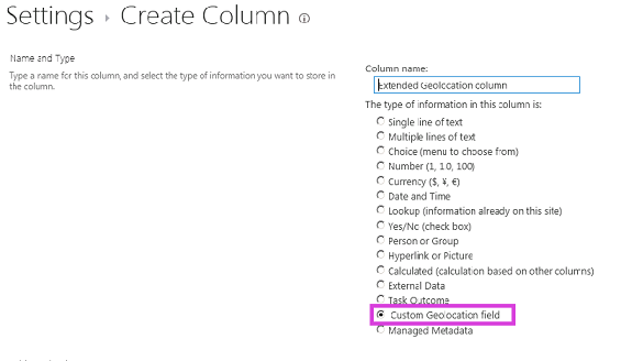
创建自定义列表,并添加新的“自定义地理位置”字段列。
向列表中添加一项,并为自定义地理位置列提供经度值和纬度值。
图 2 显示了使用新自定义字段类型的创建列页面。
图 2. 创建新自定义字段类型列