Note
Access to this page requires authorization. You can try signing in or changing directories.
Access to this page requires authorization. You can try changing directories.
This article shows you how to make a route request and show the route on the map.
There are two ways to do so. The first way is to query the Get Route Directions API using the TypeScript REST SDK @azure-rest/maps-route. The second way is to use the Fetch API to make a search request to the Get Route Directions API. Both approaches are described in this article.
Query the route via REST SDK
import * as atlas from "azure-maps-control";
import MapsRoute, { toColonDelimitedLatLonString } from "@azure-rest/maps-route";
import "azure-maps-control/dist/atlas.min.css";

const onload = () => {
  // Initialize a map instance.
  const map = new atlas.Map("map", {
    view: "Auto",
    // Add authentication details for connecting to Azure Maps.
    authOptions: {
      // Use Azure Active Directory authentication.
      authType: "aad",
      clientId: "<Your Azure Maps Client ID>",
      aadAppId: "<Your Azure Active Directory Client ID>",
      aadTenant: "<Your Azure Active Directory Tenant ID>"
    }
  });

  map.events.add("load", async () => {
    // Use the access token from the map and create an object that implements the TokenCredential interface.
    const credential = {
      getToken: () => {
        return {
          token: map.authentication.getToken()
        };
      }
    };

    // Create a Route client.
    const client = MapsRoute(credential, "<Your Azure Maps Client ID>");

    // Create a data source and add it to the map.
    const dataSource = new atlas.source.DataSource();
    map.sources.add(dataSource);

    // Create the GeoJSON objects which represent the start and end points of the route.
    const startPoint = new atlas.data.Feature(new atlas.data.Point([-122.130137, 47.644702]), {
      title: "Redmond",
      icon: "pin-blue"
    });

    const endPoint = new atlas.data.Feature(new atlas.data.Point([-122.3352, 47.61397]), {
      title: "Seattle",
      icon: "pin-round-blue"
    });

    // Add the data to the data source.
    dataSource.add([startPoint, endPoint]);

    // Create a layer for rendering the route line under the road labels.
    map.layers.add(
      new atlas.layer.LineLayer(dataSource, null, {
        strokeColor: "#2272B9",
        strokeWidth: 5,
        lineJoin: "round",
        lineCap: "round"
      }),
      "labels"
    );

    // Create a layer for rendering the start and end points of the route as symbols.
    map.layers.add(
      new atlas.layer.SymbolLayer(dataSource, null, {
        iconOptions: {
          image: ["get", "icon"],
          allowOverlap: true,
          ignorePlacement: true
        },
        textOptions: {
          textField: ["get", "title"],
          offset: [0, 1.2]
        },
        filter: ["any", ["==", ["geometry-type"], "Point"], ["==", ["geometry-type"], "MultiPoint"]] //Only render Point or MultiPoints in this layer.
      })
    );

    // Get the coordinates of the start and end points.
    const coordinates = [
      [startPoint.geometry.coordinates[1], startPoint.geometry.coordinates[0]],
      [endPoint.geometry.coordinates[1], endPoint.geometry.coordinates[0]]
    ];

    // Get the route directions between the start and end points.
    const response = await client.path("/route/directions/{format}", "json").get({
      queryParameters: {
        query: toColonDelimitedLatLonString(coordinates)
      }
    });

    // Get the GeoJSON feature collection of the route.
    const data = getFeatures(response.body.routes);

    // Add the route data to the data source.
    dataSource.add(data);

    // Update the map view to center over the route.
    map.setCamera({
      bounds: data.bbox,
      padding: 40
    });
  });
};

/**
 * Helper function to convert a route response into a GeoJSON FeatureCollection.
 */
const getFeatures = (routes) => {
  const bounds = [];
  const features = routes.map((route, index) => {
    const multiLineCoords = route.legs.map((leg) => {
      return leg.points.map((coord) => {
        const position = [coord.longitude, coord.latitude];
        bounds.push(position);
        return position;
      });
    });

    // Include all properties on the route object except legs.
    // Legs is used to create the MultiLineString, so we only need the summaries.
    // The legSummaries property replaces the legs property with just summary data.
    const props = {
      ...route,
      legSummaries: route.legs.map((leg) => leg.summary),
      resultIndex: index
    };
    delete props.legs;

    return {
      type: "Feature",
      geometry: {
        type: "MultiLineString",
        coordinates: multiLineCoords
      },
      properties: props
    };
  });

  return {
    type: "FeatureCollection",
    features: features,
    bbox: new atlas.data.BoundingBox.fromLatLngs(bounds)
  };
};

document.body.onload = onload;
In the previous code example, the first block constructs a map object and sets the authentication mechanism to use Microsoft Entra ID. You can see Create a map for instructions.
The second block of code creates an object that implements the TokenCredential interface to authenticate HTTP requests to Azure Maps with the access token. It then passes the credential object to MapsRoute and creates an instance of the client.
The third block of code creates and adds a DataSource object to the map.
The fourth block of code creates start and end points objects and adds them to the dataSource object.
A line is a Feature for LineString. A LineLayer renders line objects wrapped in the DataSource as lines on the map. The fourth block of code creates and adds a line layer to the map. See properties of a line layer at LinestringLayerOptions.
A symbol layer uses texts or icons to render point-based data wrapped in the DataSource. The texts or the icons render as symbols on the map. The fifth block of code creates and adds a symbol layer to the map.
The sixth block of code queries the Azure Maps routing service, which is part of the MapsRoute client. A GET request is used to get a route between the start and end points. A GeoJSON feature collection from the response is then extracted using a getFeatures() helper function and is added to the datasource. It then renders the response as a route on the map. For more information about adding a line to the map, see Add a line on the map.
The last block of code sets the bounds of the map using the Map's setCamera property.
The route query, data source, symbol, line layers, and camera bounds are created inside the event listener. This code structure ensures the results are displayed only after the map fully loads.
Query the route via Fetch API
import * as atlas from "azure-maps-control";
import "azure-maps-control/dist/atlas.min.css";

const onload = () => {
  // Initialize a map instance.
  const map = new atlas.Map("map", {
    view: "Auto",
    // Add authentication details for connecting to Azure Maps.
    authOptions: {
      // Use Azure Active Directory authentication.
      authType: "aad",
      clientId: "<Your Azure Maps Client ID>",
      aadAppId: "<Your Azure Active Directory Client ID>",
      aadTenant: "<Your Azure Active Directory Tenant ID>"
    }
  });

  map.events.add("load", async () => {
    // Create a data source and add it to the map.
    const dataSource = new atlas.source.DataSource();
    map.sources.add(dataSource);

    // Create the GeoJSON objects which represent the start and end points of the route.
    const startPoint = new atlas.data.Feature(new atlas.data.Point([-122.130137, 47.644702]), {
      title: "Redmond",
      icon: "pin-blue"
    });

    const endPoint = new atlas.data.Feature(new atlas.data.Point([-122.3352, 47.61397]), {
      title: "Seattle",
      icon: "pin-round-blue"
    });

    // Add the data to the data source.
    dataSource.add([startPoint, endPoint]);

    // Create a layer for rendering the route line under the road labels.
    map.layers.add(
      new atlas.layer.LineLayer(dataSource, null, {
        strokeColor: "#2272B9",
        strokeWidth: 5,
        lineJoin: "round",
        lineCap: "round"
      }),
      "labels"
    );

    // Create a layer for rendering the start and end points of the route as symbols.
    map.layers.add(
      new atlas.layer.SymbolLayer(dataSource, null, {
        iconOptions: {
          image: ["get", "icon"],
          allowOverlap: true,
          ignorePlacement: true
        },
        textOptions: {
          textField: ["get", "title"],
          offset: [0, 1.2]
        },
        filter: ["any", ["==", ["geometry-type"], "Point"], ["==", ["geometry-type"], "MultiPoint"]] //Only render Point or MultiPoints in this layer.
      })
    );

    // Send a request to the route API
    let url = "https://atlas.microsoft.com/route/directions/json?";
    url += "&api-version=1.0";
    url +=
      "&query=" +
      startPoint.geometry.coordinates[1] +
      "," +
      startPoint.geometry.coordinates[0] +
      ":" +
      endPoint.geometry.coordinates[1] +
      "," +
      endPoint.geometry.coordinates[0];

    // Process request
    fetch(url, {
      headers: {
        Authorization: "Bearer " + map.authentication.getToken(),
        "x-ms-client-id": "<Your Azure Maps Client ID>"
      }
    })
      .then((response) => response.json())
      .then((response) => {
        const bounds = [];
        const route = response.routes[0];

        // Create an array to store the coordinates of each turn
        let routeCoordinates = [];
        route.legs.forEach((leg) => {
          const legCoordinates = leg.points.map((point) => {
            const position = [point.longitude, point.latitude];
            bounds.push(position);
            return position;
          });
          // Add each turn coordinate to the array
          routeCoordinates = routeCoordinates.concat(legCoordinates);
        });

        // Add route line to the dataSource
        dataSource.add(new atlas.data.Feature(new atlas.data.LineString(routeCoordinates)));

        // Update the map view to center over the route.
        map.setCamera({
          bounds: new atlas.data.BoundingBox.fromLatLngs(bounds),
          padding: 40
        });
      });
  });
};

document.body.onload = onload;
In the previous code example, the first block of code constructs a map object and sets the authentication mechanism to use Microsoft Entra ID. You can see Create a map for instructions.
The second block of code creates and adds a DataSource object to the map.
The third code block creates the start and destination points for the route. Then, it adds them to the data source. For more information, see Add a pin on the map.
A LineLayer renders line objects wrapped in the DataSource as lines on the map. The fourth block of code creates and adds a line layer to the map. See properties of a line layer at LineLayerOptions.
A symbol layer uses text or icons to render point-based data wrapped in the DataSource as symbols on the map. The fifth block of code creates and adds a symbol layer to the map. See properties of a symbol layer at SymbolLayerOptions.
The next block of code uses the Fetch API to make a search request to Get Route Directions. The response is then parsed. If the response was successful, the latitude and longitude information is used to create an array a line by connecting those points. The line data is then added to data source to render the route on the map. For more information, see Add a line on the map.
The last block of code sets the bounds of the map using the Map's setCamera property.
The route query, data source, symbol, line layers, and camera bounds are created inside the event listener. Again, we want to ensure that results are displayed after the map loads fully.
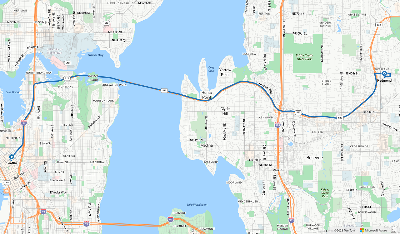
The following image is a screenshot showing the results of the two code samples.
Next steps
Learn more about the classes and methods used in this article:
See the following articles for full code examples: