Note
Access to this page requires authorization. You can try signing in or changing directories.
Access to this page requires authorization. You can try changing directories.
The Bing Maps Spatial Data Services (SDS) has several capabilities similar to Azure Maps and other Azure services. Bing Maps SDS supports storing, managing, and querying your custom spatial data using the SDS Data Source Management and Query API, querying public points of interest data using the SDS Public Data Sources and Query API, batch geocoding location data using the SDS Geocode Dataflow API and getting geographical polygon boundaries using the SDS Geodata API.
This article covers alternatives to the SDS functionality for storing, managing, and querying your custom spatial data sources. If you need guidance on migrating from the other SDS capabilities to Azure Maps, refer to the following migration guides.
Prerequisites
- An Azure Account
- An Azure Maps account
- A subscription key or other form of Authentication with Azure Maps
Bing Maps SDS Data Source Management and Query API alternatives
Azure Maps in combination with other Azure services offer state of the art solutions for storing, managing, and performing spatial querying on your custom location data. All while handling security, compliance, and privacy requirements. Azure has several alternative solutions to the Bing Maps SDS Data Source Management and Query API available to you.
Azure Maps integrates with other Azure services to store, manage, and perform spatial querying on your custom spatial data sources. For example, Azure offers several database products that support geospatial data capabilities, such as the following database products:
- Azure SQL Database: A relational database that supports geography and geometry data types and spatial methods, such as STArea, STDistance, STIntersects, STWithin, and many more.
- Azure Cosmos DB: A NoSQL database that supports GeoJSON data types and spatial queries, such as ST_AREA, ST_DISTANCE, ST_WITHIN, ST_INTERSECTS, ST_ISVALID, and ST_ISVALIDDETAILED.
- Azure Database for PostgreSQL: An open-source relational database that supports PostGIS, an extension that adds support for geographic objects and spatial functions, such as ST_Area, ST_Distance, ST_Within, ST_Intersects, ST_IsValid, and ST_IsValidReason.
To load and present your data on a map, you need to build a service layer (an API) that is used by the Azure Maps Web SDK client to get the data that needs to be displayed on the map. The following illustration is a simple architecture design showing what you need for this scenario:

More information
- Create a data source for a map in Microsoft Azure Maps
- How to use the Azure Maps Spatial IO module
- Read and write spatial data with Microsoft Azure Maps
Locator starter project
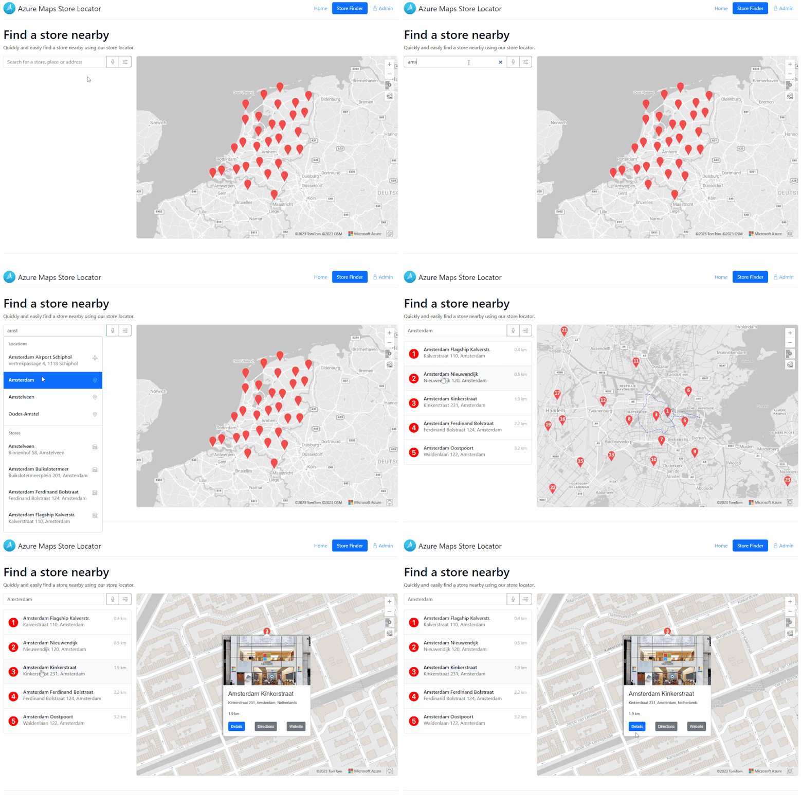
If you need a locator solution, such as a store locator, job searching by location or finding a house to buy or rent, we have a store locator starter project that uses Azure Maps and Azure Cosmos DB to get you started quickly. The Azure Maps Store Locator provides an impressive range of capabilities to enhance your location-based services:
- Store Locator Backend: Offers REST APIs and a ‘Store Locator Web Control’.
- Robust Autocomplete Search: Enables searching for store names, addresses, points of interest (POI), or zip codes.
- High Location Capacity: Supports over 10,000 locations.
- Proximity Insights: Displays nearby stores and their respective distances.
- Location-based Search: Allows searching based on the user's or device's location.
- Travel Time Estimates: Presents travel time for walking and driving options.
- Detailed Store Information: Offers store details via popups and directions.
- Dynamic Filtering: Allows the user to filter based on dynamic store features.
- Detailed Store Page: Explore what a specific store offers with an embedded map.
- Security Measures: Utilizes Microsoft Entra ID for secure location management system access, ensuring only authorized employees can update store details. For more information, see Microsoft Entra authentication.
- Rich Store Data: Includes store details such as location, opening hours, store photos, and facilitates the addition of custom store features and services.
- Accessibility Features: Incorporates speech recognition and other accessibility options.
- Seamless Deployment: Easy deployment within your Azure subscription.

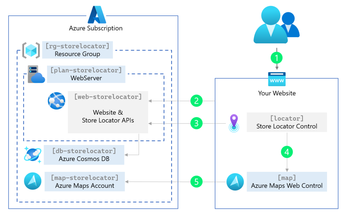
The Azure Maps store locator starter project gives you the following general architecture that you can customize and expand on to meet your specific business requirements.

Additional information
- Azure-Samples/Azure-Maps-Locator: Azure Maps Locator Source Code (github.com)
- Azure Maps Store Locator Blog Post (microsoft.com)
- Tutorial: Use Azure Maps to create store locator